Heimsheim geodata
Heimsheim (Baden-Württemberg) is a populated place; located in Germany in Europe/Berlin (GMT+2) time zone. With population of 5,234 people, there are 2722 cities with bigger population in this country. Compared to other cities in Germany, 85.3% of cities are located further ↑North; 67% of cities are located further →East and 76.1% of cities have lower elevation than Heimsheim. Note1
Administrative division(s):
- Level 1: Baden-Württemberg
- Level 2: Karlsruhe Region
- Level 3: Enzkreis
- Level 4: Heimsheim


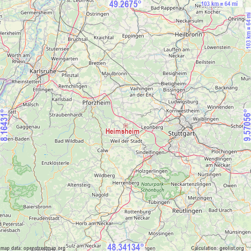
Heimsheim GPS coordinates[2]
48° 48' 23.616" North, 8° 52' 2.784" East
| Map corner | latitude | longitude |
|---|---|---|
| Upper-left | 49.2675°, | 8.16431° |
| Center: | 48.80656°, | 8.86744° |
| Lower-right: | 48.34134°, | 9.57056° |
| Map W x H: | 103×103 km | = 64×64mi |
| max Lat: | 55.01917° ⇑85.3% North |
| Heimsheim: | 48.80656° |
| min Lat: | ⇓14.7% South 47.40724° |
| min Long | Heimsheim | max Long |
| 5.92978° | 8.86744° | 14.98853° |
| W 33%⇐ | ⇒67% E |
Elevation
Elevation of Heimsheim is 406 m = 1332 ft, and this is 156.9 m = 515 ft above average elevation for this country.
| Max E: |
1256 m = 4121 ft | 23.9% |
| Heimsheim | 406 m 1332 ft | |
| Avg. | 249.1 m = 817 ft | |
Min E: |
-5 m = -16 ft | 76.1% |
See also: Germany elevation on elevation.city.
Geographical zone
Heimsheim is located in North temperate zone (between Tropic of Cancer and the Arctic Circle). Distance of this North polar circle is 1974.4 km =1226.8 mi to North.| Distance of | km | miles | from Heimsheim |
|---|---|---|---|
| North Pole | 4580.3 | 2846.1 | to North |
| Arctic Circle | 1974.4 | 1226.8 | to North |
| Tropic Cancer | 2820.9 | 1752.8 | to South |
| Equator | 5426.8 | 3372.1 | to South |


Nearby cities:
15 places around Heimsheim: (largest is in red/bold)
• Althengstett
10.7 km =6.6 mi,  210°
210°
• Friolzheim
3.9 km =2.4 mi,  320°
320°
• Magstadt
10 km =6.2 mi,  133°
133°
• Mönsheim
6.7 km =4.2 mi,  359°
359°
• Neuhausen
6.8 km =4.2 mi,  256°
256°
• Ostelsheim
9 km =5.6 mi,  189°
189°
• Renningen
6.6 km =4.1 mi, 128°
• Rutesheim
5.7 km =3.5 mi,  88°
88°
• Simmozheim
7.4 km =4.6 mi, 213°
• Tiefenbronn
5.2 km =3.2 mi,  291°
291°
• Weil der Stadt
6.3 km =3.9 mi,  177°
177°
• Weissach
6.3 km =3.9 mi,  44°
44°
• Wiernsheim
8.6 km =5.3 mi,  351°
351°
• Wimsheim
5.4 km =3.4 mi,  332°
332°
• Wurmberg
7.6 km =4.7 mi, 330°
Sources, notices
• [Note1] Compared only with cities in Germany existing in our database
• [Src1] Map data: © OpenStreetMap contributors (CC-BY-SA)
• [Src2] Other city data from geonames.org with taken over terms of usage.
• [Src3] Geographical zone / Annual Mean Temperature by Robert A. Rohde @ Wikipedia
