Eberdingen geodata
Eberdingen (Baden-Württemberg) is a seat of a fourth-order administrative division; located in Germany in Europe/Berlin (GMT+2) time zone. With population of 6,518 people, there are 2305 cities with bigger population in this country. Compared to other cities in Germany, 84.4% of cities are located further ↑North; 65.9% of cities are located further →East and 56% of cities have lower elevation than Eberdingen. Note1
Administrative division(s):
- Level 1: Baden-Württemberg
- Level 2: Regierungsbezirk Stuttgart
- Level 3: Landkreis Ludwigsburg
- Level 4: Eberdingen


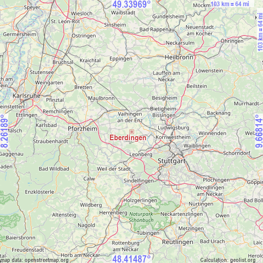
Eberdingen GPS coordinates[2]
48° 52' 45.912" North, 8° 57' 54.072" East
| Map corner | latitude | longitude |
|---|---|---|
| Upper-left | 49.33969°, | 8.26189° |
| Center: | 48.87942°, | 8.96502° |
| Lower-right: | 48.41487°, | 9.66814° |
| Map W x H: | 102.8×102.8 km | = 63.9×63.9mi |
| max Lat: | 55.01917° ⇑84.4% North |
| Eberdingen: | 48.87942° |
| min Lat: | ⇓15.6% South 47.40724° |
| min Long | Eberdingen | max Long |
| 5.92978° | 8.96502° | 14.98853° |
| W 34.1%⇐ | ⇒65.9% E |
Elevation
Elevation of Eberdingen is 266 m = 873 ft, and this is 16.9 m = 55 ft above average elevation for this country.
| Max E: |
1256 m = 4121 ft | 44% |
| Eberdingen | 266 m 873 ft | |
| Avg. | 249.1 m = 817 ft | |
Min E: |
-5 m = -16 ft | 56% |
See also: Germany elevation on elevation.city.
Geographical zone
Eberdingen is located in North temperate zone (between Tropic of Cancer and the Arctic Circle). Distance of this North polar circle is 1966.3 km =1221.8 mi to North.| Distance of | km | miles | from Eberdingen |
|---|---|---|---|
| North Pole | 4572.2 | 2841 | to North |
| Arctic Circle | 1966.3 | 1221.8 | to North |
| Tropic Cancer | 2829 | 1757.9 | to South |
| Equator | 5434.9 | 3377.1 | to South |


Nearby cities:
15 places around Eberdingen: (largest is in red/bold)
• Ditzingen
9.5 km =5.9 mi,  128°
128°
• Heimsheim
10.8 km =6.7 mi,  221°
221°
• Hemmingen
5.2 km =3.2 mi,  105°
105°
• Illingen
9 km =5.6 mi,  340°
340°
• Leonberg
9.6 km =6 mi,  156°
156°
• Markgröningen
8.9 km =5.5 mi,  71°
71°
• Mönsheim
7.3 km =4.5 mi,  258°
258°
• Oberriexingen
6.9 km =4.3 mi,  40°
40°
• Rutesheim
8.1 km =5 mi,  190°
190°
• Schwieberdingen
8 km =5 mi,  92°
92°
• Sersheim
10.4 km =6.5 mi,  21°
21°
• Vaihingen an der Enz
6.3 km =3.9 mi,  356°
356°
• Weissach
4.5 km =2.8 mi, 216°
• Wiernsheim
8.4 km =5.2 mi,  272°
272°
• Wimsheim
10.2 km =6.3 mi,  251°
251°
Sources, notices
• [Note1] Compared only with cities in Germany existing in our database
• [Src1] Map data: © OpenStreetMap contributors (CC-BY-SA)
• [Src2] Other city data from geonames.org with taken over terms of usage.
• [Src3] Geographical zone / Annual Mean Temperature by Robert A. Rohde @ Wikipedia
