Ditzingen geodata
Ditzingen (Baden-Württemberg) is a populated place; located in Germany in Europe/Berlin (GMT+2) time zone. With population of 24,149 people, there are 619 cities with bigger population in this country. Compared to other cities in Germany, 85% of cities are located further ↑North; 64.4% of cities are located further →East and 61.7% of cities have lower elevation than Ditzingen. Note1
Administrative division(s):
- Level 1: Baden-Württemberg
- Level 2: Regierungsbezirk Stuttgart
- Level 3: Landkreis Ludwigsburg
- Level 4: Ditzingen


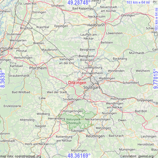
Ditzingen GPS coordinates[2]
48° 49' 36.192" North, 9° 4' 1.308" East
| Map corner | latitude | longitude |
|---|---|---|
| Upper-left | 49.28748°, | 8.3639° |
| Center: | 48.82672°, | 9.06703° |
| Lower-right: | 48.36169°, | 9.77015° |
| Map W x H: | 102.9×102.9 km | = 63.9×63.9mi |
| max Lat: | 55.01917° ⇑85% North |
| Ditzingen: | 48.82672° |
| min Lat: | ⇓15% South 47.40724° |
| min Long | Ditzingen | max Long |
| 5.92978° | 9.06703° | 14.98853° |
| W 35.6%⇐ | ⇒64.4% E |
Elevation
Elevation of Ditzingen is 300 m = 984 ft, and this is 50.9 m = 167 ft above average elevation for this country.
| Max E: |
1256 m = 4121 ft | 38.3% |
| Ditzingen | 300 m 984 ft | |
| Avg. | 249.1 m = 817 ft | |
Min E: |
-5 m = -16 ft | 61.7% |
See also: Germany elevation on elevation.city.
Geographical zone
Ditzingen is located in North temperate zone (between Tropic of Cancer and the Arctic Circle). Distance of this North polar circle is 1972.2 km =1225.5 mi to North.| Distance of | km | miles | from Ditzingen |
|---|---|---|---|
| North Pole | 4578 | 2844.6 | to North |
| Arctic Circle | 1972.2 | 1225.5 | to North |
| Tropic Cancer | 2823.1 | 1754.2 | to South |
| Equator | 5429 | 3373.4 | to South |


Nearby cities:
15 places around Ditzingen: (largest is in red/bold)
• Asperg
10 km =6.2 mi,  29°
29°
• Eberdingen
9.5 km =5.9 mi,  308°
308°
• Gerlingen
3 km =1.9 mi,  185°
185°
• Hemmingen
5.1 km =3.2 mi,  330°
330°
• Korntal
4 km =2.5 mi,  81°
81°
• Kornwestheim
9.5 km =5.9 mi,  65°
65°
• Leonberg
4.7 km =2.9 mi,  231°
231°
• Markgröningen
8.8 km =5.5 mi,  6°
6°
• Möglingen
8 km =5 mi, 33°
• Rutesheim
9.1 km =5.7 mi,  256°
256°
• Schwieberdingen
5.6 km =3.5 mi, 5°
• Stuttgart
9.4 km =5.8 mi,  121°
121°
• Stuttgart Feuerbach
6.9 km =4.3 mi,  106°
106°
• Tamm
10.9 km =6.8 mi,  18°
18°
• Weissach
10.4 km =6.5 mi,  282°
282°
Sources, notices
• [Note1] Compared only with cities in Germany existing in our database
• [Src1] Map data: © OpenStreetMap contributors (CC-BY-SA)
• [Src2] Other city data from geonames.org with taken over terms of usage.
• [Src3] Geographical zone / Annual Mean Temperature by Robert A. Rohde @ Wikipedia
