Wehr geodata
Wehr (Baden-Württemberg) is a populated place; located in Germany in Europe/Berlin (GMT+2) time zone. With population of 13,037 people, there are 1236 cities with bigger population in this country. Compared to other cities in Germany, 99.4% of cities are located further ↑North; 78.8% of cities are located further →East and 70% of cities have lower elevation than Wehr. Note1
Administrative division(s):
- Level 1: Baden-Württemberg
- Level 2: Freiburg Region
- Level 3: Landkreis Waldshut
- Level 4: Wehr


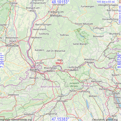
Wehr GPS coordinates[2]
47° 37' 47.388" North, 7° 54' 15.228" East
| Map corner | latitude | longitude |
|---|---|---|
| Upper-left | 48.10153°, | 7.20111° |
| Center: | 47.62983°, | 7.90423° |
| Lower-right: | 47.15383°, | 8.60736° |
| Map W x H: | 105.4×105.4 km | = 65.5×65.5mi |
| max Lat: | 55.01917° ⇑99.4% North |
| Wehr: | 47.62983° |
| min Lat: | ⇓0.6% South 47.40724° |
| min Long | Wehr | max Long |
| 5.92978° | 7.90423° | 14.98853° |
| W 21.2%⇐ | ⇒78.8% E |
Elevation
Elevation of Wehr is 358 m = 1175 ft, and this is 108.9 m = 357 ft above average elevation for this country.
| Max E: |
1256 m = 4121 ft | 30% |
| Wehr | 358 m 1175 ft | |
| Avg. | 249.1 m = 817 ft | |
Min E: |
-5 m = -16 ft | 70% |
See also: Germany elevation on elevation.city.
Geographical zone
Wehr is located in North temperate zone (between Tropic of Cancer and the Arctic Circle). Distance of this North polar circle is 2105.2 km =1308.1 mi to North.| Distance of | km | miles | from Wehr |
|---|---|---|---|
| North Pole | 4711.1 | 2927.3 | to North |
| Arctic Circle | 2105.2 | 1308.1 | to North |
| Tropic Cancer | 2690 | 1671.5 | to South |
| Equator | 5295.9 | 3290.7 | to South |


Nearby cities:
15 places around Wehr: (largest is in red/bold)
• Bad Säckingen
9 km =5.6 mi,  159°
159°
• Görwihl
12.9 km =8 mi,  83°
83°
• Hasel
2.7 km =1.7 mi,  348°
348°
• Hausen
7.5 km =4.7 mi,  319°
319°
• Herrischried
8.3 km =5.2 mi,  60°
60°
• Laufenburg
13.7 km =8.5 mi,  121°
121°
• Maulburg
9.3 km =5.8 mi,  281°
281°
• Murg
12.1 km =7.5 mi,  133°
133°
• Rheinfelden
11.7 km =7.3 mi,  228°
228°
• Rickenbach
5.7 km =3.5 mi,  102°
102°
• Schopfheim
6.7 km =4.2 mi,  290°
290°
• Schwörstadt
4.5 km =2.8 mi,  205°
205°
• Steinen
12.5 km =7.8 mi, 277°
• Wieslet
10.3 km =6.4 mi,  309°
309°
• Zell im Wiesental
9.3 km =5.8 mi,  335°
335°
Sources, notices
• [Note1] Compared only with cities in Germany existing in our database
• [Src1] Map data: © OpenStreetMap contributors (CC-BY-SA)
• [Src2] Other city data from geonames.org with taken over terms of usage.
• [Src3] Geographical zone / Annual Mean Temperature by Robert A. Rohde @ Wikipedia
