Görwihl geodata
Görwihl (Baden-Württemberg) is a seat of a fourth-order administrative division; located in Germany in Europe/Berlin (GMT+2) time zone. With population of 4,587 people, there are 2992 cities with bigger population in this country. Compared to other cities in Germany, 99.3% of cities are located further ↑North; 75.8% of cities are located further →East and 97.5% of cities have lower elevation than Görwihl. Note1
Administrative division(s):
- Level 1: Baden-Württemberg
- Level 2: Freiburg Region
- Level 3: Landkreis Waldshut
- Level 4: Görwihl


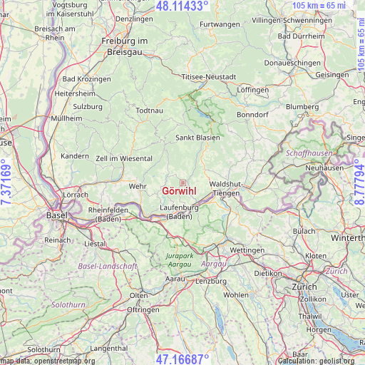
Görwihl GPS coordinates[2]
47° 38' 33.9" North, 8° 4' 29.352" East
| Map corner | latitude | longitude |
|---|---|---|
| Upper-left | 48.11433°, | 7.37169° |
| Center: | 47.64275°, | 8.07482° |
| Lower-right: | 47.16687°, | 8.77794° |
| Map W x H: | 105.3×105.3 km | = 65.4×65.4mi |
| max Lat: | 55.01917° ⇑99.3% North |
| Görwihl: | 47.64275° |
| min Lat: | ⇓0.7% South 47.40724° |
| min Long | Görwihl | max Long |
| 5.92978° | 8.07482° | 14.98853° |
| W 24.2%⇐ | ⇒75.8% E |
Elevation
Elevation of Görwihl is 685 m = 2247 ft, and this is 435.9 m = 1430 ft above average elevation for this country.
| Max E: |
1256 m = 4121 ft | 2.5% |
| Görwihl | 685 m 2247 ft | |
| Avg. | 249.1 m = 817 ft | |
Min E: |
-5 m = -16 ft | 97.5% |
See also: Germany elevation on elevation.city.
Geographical zone
Görwihl is located in North temperate zone (between Tropic of Cancer and the Arctic Circle). Distance of this North polar circle is 2103.8 km =1307.2 mi to North.| Distance of | km | miles | from Görwihl |
|---|---|---|---|
| North Pole | 4709.7 | 2926.5 | to North |
| Arctic Circle | 2103.8 | 1307.2 | to North |
| Tropic Cancer | 2691.5 | 1672.4 | to South |
| Equator | 5297.4 | 3291.7 | to South |


Nearby cities:
15 places around Görwihl: (largest is in red/bold)
• Albbruck
7.1 km =4.4 mi,  144°
144°
• Dachsberg
9.8 km =6.1 mi,  11°
11°
• Dogern
7.8 km =4.8 mi,  118°
118°
• Hasel
13.4 km =8.3 mi,  275°
275°
• Herrischried
6.2 km =3.9 mi,  295°
295°
• Häusern
13.8 km =8.6 mi,  29°
29°
• Höchenschwand
12.2 km =7.6 mi, 34°
• Ibach
10.1 km =6.3 mi,  356°
356°
• Laufenburg
8.7 km =5.4 mi,  187°
187°
• Murg
10.5 km =6.5 mi,  202°
202°
• Rickenbach
7.7 km =4.8 mi,  249°
249°
• Todtmoos
12.1 km =7.5 mi,  333°
333°
• Waldshut-Tiengen
10.9 km =6.8 mi,  101°
101°
• Wehr
12.9 km =8 mi,  263°
263°
• Weilheim
12.2 km =7.6 mi,  77°
77°
Sources, notices
• [Note1] Compared only with cities in Germany existing in our database
• [Src1] Map data: © OpenStreetMap contributors (CC-BY-SA)
• [Src2] Other city data from geonames.org with taken over terms of usage.
• [Src3] Geographical zone / Annual Mean Temperature by Robert A. Rohde @ Wikipedia
