Hasel geodata
Hasel (Baden-Württemberg) is a seat of a fourth-order administrative division; located in Germany in Europe/Berlin (GMT+2) time zone. With population of 1,115 people, there are 6810 cities with bigger population in this country. Compared to other cities in Germany, 99.2% of cities are located further ↑North; 79% of cities are located further →East and 75.5% of cities have lower elevation than Hasel. Note1
Administrative division(s):
- Level 1: Baden-Württemberg
- Level 2: Freiburg Region
- Level 3: Landkreis Lörrach
- Level 4: Hasel


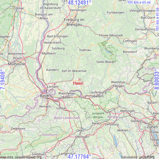
Hasel GPS coordinates[2]
47° 39' 12.312" North, 7° 53' 49.92" East
| Map corner | latitude | longitude |
|---|---|---|
| Upper-left | 48.12491°, | 7.19408° |
| Center: | 47.65342°, | 7.8972° |
| Lower-right: | 47.17764°, | 8.60033° |
| Map W x H: | 105.3×105.3 km | = 65.4×65.4mi |
| max Lat: | 55.01917° ⇑99.2% North |
| Hasel: | 47.65342° |
| min Lat: | ⇓0.8% South 47.40724° |
| min Long | Hasel | max Long |
| 5.92978° | 7.8972° | 14.98853° |
| W 21%⇐ | ⇒79% E |
Elevation
Elevation of Hasel is 401 m = 1316 ft, and this is 151.9 m = 498 ft above average elevation for this country.
| Max E: |
1256 m = 4121 ft | 24.5% |
| Hasel | 401 m 1316 ft | |
| Avg. | 249.1 m = 817 ft | |
Min E: |
-5 m = -16 ft | 75.5% |
See also: Germany elevation on elevation.city.
Geographical zone
Hasel is located in North temperate zone (between Tropic of Cancer and the Arctic Circle). Distance of this North polar circle is 2102.6 km =1306.5 mi to North.| Distance of | km | miles | from Hasel |
|---|---|---|---|
| North Pole | 4708.5 | 2925.7 | to North |
| Arctic Circle | 2102.6 | 1306.5 | to North |
| Tropic Cancer | 2692.6 | 1673.1 | to South |
| Equator | 5298.6 | 3292.4 | to South |


Nearby cities:
15 places around Hasel: (largest is in red/bold)
• Bad Säckingen
11.7 km =7.3 mi,  161°
161°
• Görwihl
13.4 km =8.3 mi,  95°
95°
• Hausen
5.3 km =3.3 mi,  305°
305°
• Herrischried
7.8 km =4.8 mi,  79°
79°
• Maulburg
8.7 km =5.4 mi,  264°
264°
• Rheinfelden
13.3 km =8.3 mi,  218°
218°
• Rickenbach
7.2 km =4.5 mi,  122°
122°
• Schopfheim
5.7 km =3.5 mi,  267°
267°
• Schwörstadt
6.8 km =4.2 mi,  191°
191°
• Steinen
11.9 km =7.4 mi, 265°
• Todtmoos
12.4 km =7.7 mi,  39°
39°
• Wehr
2.7 km =1.7 mi,  168°
168°
• Wembach
13.3 km =8.3 mi,  356°
356°
• Wieslet
8.4 km =5.2 mi,  297°
297°
• Zell im Wiesental
6.7 km =4.2 mi,  329°
329°
Sources, notices
• [Note1] Compared only with cities in Germany existing in our database
• [Src1] Map data: © OpenStreetMap contributors (CC-BY-SA)
• [Src2] Other city data from geonames.org with taken over terms of usage.
• [Src3] Geographical zone / Annual Mean Temperature by Robert A. Rohde @ Wikipedia
