Bad Säckingen geodata
Bad Säckingen (Baden-Württemberg) is a populated place; located in Germany in Europe/Berlin (GMT+2) time zone. With population of 16,549 people, there are 958 cities with bigger population in this country. Compared to other cities in Germany, 99.9% of cities are located further ↑North; 78.2% of cities are located further →East and 60% of cities have lower elevation than Bad Säckingen. Note1
Administrative division(s):
- Level 1: Baden-Württemberg
- Level 2: Freiburg Region
- Level 3: Landkreis Waldshut
- Level 4: Bad Säckingen


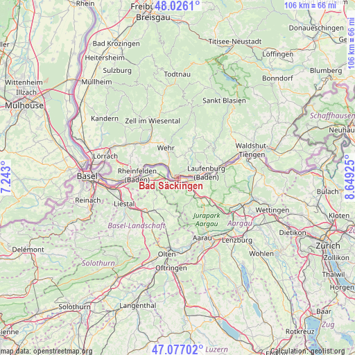
Bad Säckingen GPS coordinates[2]
47° 33' 13.356" North, 7° 56' 46.032" East
| Map corner | latitude | longitude |
|---|---|---|
| Upper-left | 48.0261°, | 7.243° |
| Center: | 47.55371°, | 7.94612° |
| Lower-right: | 47.07702°, | 8.64925° |
| Map W x H: | 105.5×105.5 km | = 65.6×65.6mi |
| max Lat: | 55.01917° ⇑99.9% North |
| Bad Säckingen: | 47.55371° |
| min Lat: | ⇓0.1% South 47.40724° |
| min Long | Bad Säckingen | max Long |
| 5.92978° | 7.94612° | 14.98853° |
| W 21.8%⇐ | ⇒78.2% E |
Elevation
Elevation of Bad Säckingen is 290 m = 951 ft, and this is 40.9 m = 134 ft above average elevation for this country.
| Max E: |
1256 m = 4121 ft | 40% |
| Bad Säckingen | 290 m 951 ft | |
| Avg. | 249.1 m = 817 ft | |
Min E: |
-5 m = -16 ft | 60% |
See also: Germany elevation on elevation.city.
Geographical zone
Bad Säckingen is located in North temperate zone (between Tropic of Cancer and the Arctic Circle). Distance of this North polar circle is 2113.7 km =1313.4 mi to North.| Distance of | km | miles | from Bad Säckingen |
|---|---|---|---|
| North Pole | 4719.6 | 2932.6 | to North |
| Arctic Circle | 2113.7 | 1313.4 | to North |
| Tropic Cancer | 2681.6 | 1666.3 | to South |
| Equator | 5287.5 | 3285.5 | to South |


Nearby cities:
15 places around Bad Säckingen: (largest is in red/bold)
• Albbruck
14.4 km =8.9 mi,  73°
73°
• Dogern
17.7 km =11 mi, 69°
• Görwihl
13.8 km =8.6 mi,  44°
44°
• Hasel
11.7 km =7.3 mi,  341°
341°
• Hausen
16.3 km =10.1 mi,  330°
330°
• Herrischried
13.2 km =8.2 mi,  17°
17°
• Laufenburg
8.7 km =5.4 mi,  81°
81°
• Maulburg
16 km =9.9 mi,  309°
309°
• Murg
5.7 km =3.5 mi,  88°
88°
• Rheinfelden
11.9 km =7.4 mi,  273°
273°
• Rickenbach
7.7 km =4.8 mi, 18°
• Schopfheim
14.3 km =8.9 mi,  319°
319°
• Schwörstadt
6.7 km =4.2 mi, 310°
• Wehr
9 km =5.6 mi, 339°
• Zell im Wiesental
18.3 km =11.4 mi, 337°
Sources, notices
• [Note1] Compared only with cities in Germany existing in our database
• [Src1] Map data: © OpenStreetMap contributors (CC-BY-SA)
• [Src2] Other city data from geonames.org with taken over terms of usage.
• [Src3] Geographical zone / Annual Mean Temperature by Robert A. Rohde @ Wikipedia
