Wehnsen geodata
Wehnsen (Lower Saxony) is a populated place; located in Germany in Europe/Berlin (GMT+2) time zone. With population of 508 people, there are 9338 cities with bigger population in this country. Compared to other cities in Germany, 76.5% of cities are located further ↓South; 54.6% of cities are located further ←West and 74.7% of cities have higher elevation than Wehnsen. Note1


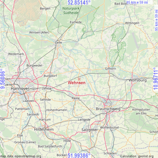
Wehnsen GPS coordinates[2]
52° 25' 28.992" North, 10° 15' 50.328" East
| Map corner | latitude | longitude |
|---|---|---|
| Upper-left | 52.85141°, | 9.56086° |
| Center: | 52.42472°, | 10.26398° |
| Lower-right: | 51.99386°, | 10.96711° |
| Map W x H: | 95.4×95.3 km | = 59.3×59.2mi |
| max Lat: | 55.01917° ⇑23.5% North |
| Wehnsen: | 52.42472° |
| min Lat: | ⇓76.5% South 47.40724° |
| min Long | Wehnsen | max Long |
| 5.92978° | 10.26398° | 14.98853° |
| W 54.6%⇐ | ⇒45.4% E |
Elevation
Elevation of Wehnsen is 64 m = 210 ft, and this is 185.1 m = 607 ft below average elevation for this country.
| Max E: |
1256 m = 4121 ft | 74.7% |
| Avg. | 249.1 m = 817 ft | |
| Wehnsen | 64 m = 210 ft | |
Min E: |
-5 m = -16 ft | 25.3% |
See also: Germany elevation on elevation.city.
Geographical zone
Wehnsen is located in North temperate zone (between Tropic of Cancer and the Arctic Circle). Distance of this North polar circle is 1572.1 km =976.9 mi to North.| Distance of | km | miles | from Wehnsen |
|---|---|---|---|
| North Pole | 4178 | 2596.1 | to North |
| Arctic Circle | 1572.1 | 976.9 | to North |
| Tropic Cancer | 3223.2 | 2002.8 | to South |
| Equator | 5829.1 | 3622 | to South |


Nearby cities:
15 places around Wehnsen: (largest is in red/bold)
• Altmerdingsen
10.1 km =6.3 mi,  295°
295°
• Arpke
11.9 km =7.4 mi,  248°
248°
• Bröckel
10.7 km =6.6 mi,  341°
341°
• Didderse
10.6 km =6.6 mi,  117°
117°
• Dollbergen
6 km =3.7 mi, 250°
• Edemissen
4.2 km =2.6 mi,  182°
182°
• Hillerse
9.3 km =5.8 mi,  95°
95°
• Leiferde
11.7 km =7.3 mi,  81°
81°
• Meerdorf
9.5 km =5.9 mi,  157°
157°
• Meinersen
8.2 km =5.1 mi,  47°
47°
• Müden
13.2 km =8.2 mi,  29°
29°
• Neubrück
12 km =7.5 mi, 119°
• Peine
11.9 km =7.4 mi,  189°
189°
• Schwüblingsen
8.8 km =5.5 mi,  260°
260°
• Uetze
6 km =3.7 mi,  318°
318°
Sources, notices
• [Note1] Compared only with cities in Germany existing in our database
• [Src1] Map data: © OpenStreetMap contributors (CC-BY-SA)
• [Src2] Other city data from geonames.org with taken over terms of usage.
• [Src3] Geographical zone / Annual Mean Temperature by Robert A. Rohde @ Wikipedia
