Arpke geodata
Arpke (Lower Saxony) is a populated place; located in Germany in Europe/Berlin (GMT+2) time zone. With population of 2,962 people, there are 4036 cities with bigger population in this country. Compared to other cities in Germany, 76.1% of cities are located further ↓South; 51.7% of cities are located further ←West and 74.1% of cities have higher elevation than Arpke. Note1


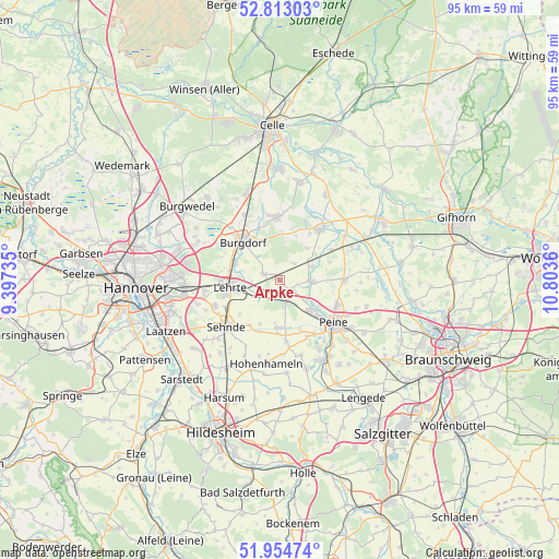
Arpke GPS coordinates[2]
52° 23' 9.492" North, 10° 6' 1.692" East
| Map corner | latitude | longitude |
|---|---|---|
| Upper-left | 52.81303°, | 9.39735° |
| Center: | 52.38597°, | 10.10047° |
| Lower-right: | 51.95474°, | 10.8036° |
| Map W x H: | 95.4×95.4 km | = 59.3×59.3mi |
| max Lat: | 55.01917° ⇑23.9% North |
| Arpke: | 52.38597° |
| min Lat: | ⇓76.1% South 47.40724° |
| min Long | Arpke | max Long |
| 5.92978° | 10.10047° | 14.98853° |
| W 51.7%⇐ | ⇒48.3% E |
Elevation
Elevation of Arpke is 67 m = 220 ft, and this is 182.1 m = 597 ft below average elevation for this country.
| Max E: |
1256 m = 4121 ft | 74.1% |
| Avg. | 249.1 m = 817 ft | |
| Arpke | 67 m = 220 ft | |
Min E: |
-5 m = -16 ft | 25.9% |
See also: Germany elevation on elevation.city.
Geographical zone
Arpke is located in North temperate zone (between Tropic of Cancer and the Arctic Circle). Distance of this North polar circle is 1576.4 km =979.5 mi to North.| Distance of | km | miles | from Arpke |
|---|---|---|---|
| North Pole | 4182.3 | 2598.8 | to North |
| Arctic Circle | 1576.4 | 979.5 | to North |
| Tropic Cancer | 3218.9 | 2000.1 | to South |
| Equator | 5824.8 | 3619.4 | to South |


Nearby cities:
15 places around Arpke: (largest is in red/bold)
• Altmerdingsen
8.9 km =5.5 mi,  12°
12°
• Bröckel
16.4 km =10.2 mi,  28°
28°
• Burgdorf
9.3 km =5.8 mi,  316°
316°
• Dollbergen
5.9 km =3.7 mi,  67°
67°
• Edemissen
10.9 km =6.8 mi,  89°
89°
• Hohenhameln
14.5 km =9 mi,  189°
189°
• Hänigsen
10.9 km =6.8 mi,  356°
356°
• Ilsede
15.2 km =9.4 mi,  153°
153°
• Lehrte
8.4 km =5.2 mi,  259°
259°
• Meerdorf
15.4 km =9.6 mi,  106°
106°
• Peine
11.8 km =7.3 mi,  129°
129°
• Schwüblingsen
3.8 km =2.4 mi,  40°
40°
• Sehnde
12 km =7.5 mi,  228°
228°
• Uetze
11.3 km =7 mi, 38°
• Wehnsen
11.9 km =7.4 mi, 68°
Sources, notices
• [Note1] Compared only with cities in Germany existing in our database
• [Src1] Map data: © OpenStreetMap contributors (CC-BY-SA)
• [Src2] Other city data from geonames.org with taken over terms of usage.
• [Src3] Geographical zone / Annual Mean Temperature by Robert A. Rohde @ Wikipedia
