Schwüblingsen geodata
Schwüblingsen (Lower Saxony) is a populated place; located in Germany in Europe/Berlin (GMT+2) time zone. With population of 598 people, there are 8837 cities with bigger population in this country. Compared to other cities in Germany, 76.3% of cities are located further ↓South; 52.3% of cities are located further ←West and 74.5% of cities have higher elevation than Schwüblingsen. Note1


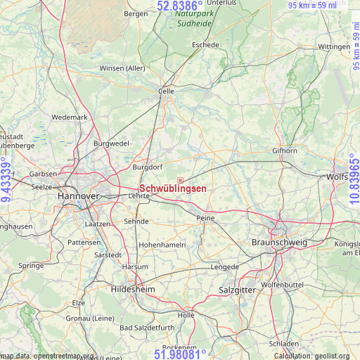
Schwüblingsen GPS coordinates[2]
52° 24' 42.444" North, 10° 8' 11.472" East
| Map corner | latitude | longitude |
|---|---|---|
| Upper-left | 52.8386°, | 9.43339° |
| Center: | 52.41179°, | 10.13652° |
| Lower-right: | 51.98081°, | 10.83965° |
| Map W x H: | 95.4×95.4 km | = 59.3×59.3mi |
| max Lat: | 55.01917° ⇑23.7% North |
| Schwüblingsen: | 52.41179° |
| min Lat: | ⇓76.3% South 47.40724° |
| min Long | Schwüblingsen | max Long |
| 5.92978° | 10.13652° | 14.98853° |
| W 52.3%⇐ | ⇒47.7% E |
Elevation
Elevation of Schwüblingsen is 65 m = 213 ft, and this is 184.1 m = 604 ft below average elevation for this country.
| Max E: |
1256 m = 4121 ft | 74.5% |
| Avg. | 249.1 m = 817 ft | |
| Schwüblingsen | 65 m = 213 ft | |
Min E: |
-5 m = -16 ft | 25.5% |
See also: Germany elevation on elevation.city.
Geographical zone
Schwüblingsen is located in North temperate zone (between Tropic of Cancer and the Arctic Circle). Distance of this North polar circle is 1573.5 km =977.7 mi to North.| Distance of | km | miles | from Schwüblingsen |
|---|---|---|---|
| North Pole | 4179.4 | 2597 | to North |
| Arctic Circle | 1573.5 | 977.7 | to North |
| Tropic Cancer | 3221.7 | 2001.9 | to South |
| Equator | 5827.6 | 3621.1 | to South |


Nearby cities:
15 places around Schwüblingsen: (largest is in red/bold)
• Altmerdingsen
5.9 km =3.7 mi,  355°
355°
• Arpke
3.8 km =2.4 mi,  220°
220°
• Bröckel
12.8 km =8 mi,  24°
24°
• Burgdorf
9.6 km =6 mi,  293°
293°
• Dollbergen
3.1 km =1.9 mi,  100°
100°
• Edemissen
8.9 km =5.5 mi,  108°
108°
• Eicklingen
15.7 km =9.8 mi,  11°
11°
• Hänigsen
8.6 km =5.3 mi,  339°
339°
• Lehrte
11.6 km =7.2 mi,  247°
247°
• Meerdorf
14.3 km =8.9 mi,  120°
120°
• Peine
12.3 km =7.6 mi,  146°
146°
• Sehnde
15.8 km =9.8 mi,  226°
226°
• Uetze
7.5 km =4.7 mi,  37°
37°
• Wathlingen
13.9 km =8.6 mi,  3°
3°
• Wehnsen
8.8 km =5.5 mi,  80°
80°
Sources, notices
• [Note1] Compared only with cities in Germany existing in our database
• [Src1] Map data: © OpenStreetMap contributors (CC-BY-SA)
• [Src2] Other city data from geonames.org with taken over terms of usage.
• [Src3] Geographical zone / Annual Mean Temperature by Robert A. Rohde @ Wikipedia
