Meinersen geodata
Meinersen (Lower Saxony) is a seat of a fourth-order administrative division; located in Germany in Europe/Berlin (GMT+2) time zone. With population of 8,322 people, there are 1900 cities with bigger population in this country. Compared to other cities in Germany, 77.2% of cities are located further ↓South; 56.4% of cities are located further ←West and 77.5% of cities have higher elevation than Meinersen. Note1


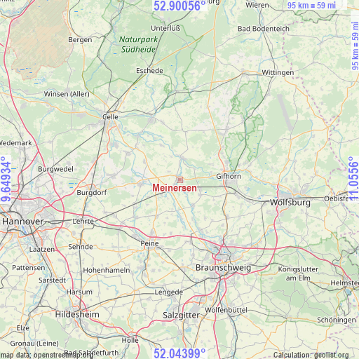
Meinersen GPS coordinates[2]
52° 28' 27.696" North, 10° 21' 8.892" East
| Map corner | latitude | longitude |
|---|---|---|
| Upper-left | 52.90056°, | 9.64934° |
| Center: | 52.47436°, | 10.35247° |
| Lower-right: | 52.04399°, | 11.0556° |
| Map W x H: | 95.2×95.2 km | = 59.2×59.2mi |
| max Lat: | 55.01917° ⇑22.8% North |
| Meinersen: | 52.47436° |
| min Lat: | ⇓77.2% South 47.40724° |
| min Long | Meinersen | max Long |
| 5.92978° | 10.35247° | 14.98853° |
| W 56.4%⇐ | ⇒43.6% E |
Elevation
Elevation of Meinersen is 54 m = 177 ft, and this is 195.1 m = 640 ft below average elevation for this country.
| Max E: |
1256 m = 4121 ft | 77.5% |
| Avg. | 249.1 m = 817 ft | |
| Meinersen | 54 m = 177 ft | |
Min E: |
-5 m = -16 ft | 22.5% |
See also: Germany elevation on elevation.city.
Geographical zone
Meinersen is located in North temperate zone (between Tropic of Cancer and the Arctic Circle). Distance of this North polar circle is 1566.6 km =973.4 mi to North.| Distance of | km | miles | from Meinersen |
|---|---|---|---|
| North Pole | 4172.5 | 2592.7 | to North |
| Arctic Circle | 1566.6 | 973.4 | to North |
| Tropic Cancer | 3228.7 | 2006.2 | to South |
| Equator | 5834.6 | 3625.5 | to South |


Nearby cities:
15 places around Meinersen: (largest is in red/bold)
• Adenbüttel
12.4 km =7.7 mi,  147°
147°
• Bröckel
10.4 km =6.5 mi,  296°
296°
• Didderse
11 km =6.8 mi,  161°
161°
• Edemissen
11.5 km =7.1 mi,  212°
212°
• Gifhorn
13.5 km =8.4 mi,  88°
88°
• Hillerse
7.2 km =4.5 mi, 153°
• Hohne
12.7 km =7.9 mi,  7°
7°
• Langlingen
10.2 km =6.3 mi,  332°
332°
• Leiferde
6.8 km =4.2 mi,  124°
124°
• Müden
6 km =3.7 mi,  4°
4°
• Neubrück
12.3 km =7.6 mi, 158°
• Ribbesbüttel
11.6 km =7.2 mi,  112°
112°
• Rötgesbüttel
13.8 km =8.6 mi, 117°
• Uetze
10.1 km =6.3 mi,  264°
264°
• Wehnsen
8.2 km =5.1 mi,  227°
227°
Sources, notices
• [Note1] Compared only with cities in Germany existing in our database
• [Src1] Map data: © OpenStreetMap contributors (CC-BY-SA)
• [Src2] Other city data from geonames.org with taken over terms of usage.
• [Src3] Geographical zone / Annual Mean Temperature by Robert A. Rohde @ Wikipedia
