Edemissen geodata
Edemissen (Lower Saxony) is a seat of a fourth-order administrative division; located in Germany in Europe/Berlin (GMT+2) time zone. With population of 3,600 people, there are 3541 cities with bigger population in this country. Compared to other cities in Germany, 76.1% of cities are located further ↓South; 54.6% of cities are located further ←West and 72.1% of cities have higher elevation than Edemissen. Note1


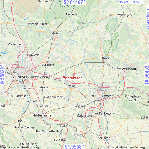
Edemissen GPS coordinates[2]
52° 23' 13.272" North, 10° 15' 41.04" East
| Map corner | latitude | longitude |
|---|---|---|
| Upper-left | 52.81407°, | 9.55828° |
| Center: | 52.38702°, | 10.2614° |
| Lower-right: | 51.9558°, | 10.96453° |
| Map W x H: | 95.4×95.4 km | = 59.3×59.3mi |
| max Lat: | 55.01917° ⇑23.9% North |
| Edemissen: | 52.38702° |
| min Lat: | ⇓76.1% South 47.40724° |
| min Long | Edemissen | max Long |
| 5.92978° | 10.2614° | 14.98853° |
| W 54.6%⇐ | ⇒45.4% E |
Elevation
Elevation of Edemissen is 77 m = 253 ft, and this is 172.1 m = 565 ft below average elevation for this country.
| Max E: |
1256 m = 4121 ft | 72.1% |
| Avg. | 249.1 m = 817 ft | |
| Edemissen | 77 m = 253 ft | |
Min E: |
-5 m = -16 ft | 27.9% |
See also: Germany elevation on elevation.city.
Geographical zone
Edemissen is located in North temperate zone (between Tropic of Cancer and the Arctic Circle). Distance of this North polar circle is 1576.3 km =979.5 mi to North.| Distance of | km | miles | from Edemissen |
|---|---|---|---|
| North Pole | 4182.2 | 2598.7 | to North |
| Arctic Circle | 1576.3 | 979.5 | to North |
| Tropic Cancer | 3219 | 2000.2 | to South |
| Equator | 5824.9 | 3619.4 | to South |


Nearby cities:
15 places around Edemissen: (largest is in red/bold)
• Adenbüttel
12.9 km =8 mi,  93°
93°
• Altmerdingsen
12.4 km =7.7 mi,  313°
313°
• Arpke
10.9 km =6.8 mi,  269°
269°
• Didderse
9.6 km =6 mi, 94°
• Dollbergen
5.9 km =3.7 mi,  291°
291°
• Hillerse
10 km =6.2 mi,  70°
70°
• Klein Schwülper
12.5 km =7.8 mi,  113°
113°
• Meerdorf
6 km =3.7 mi,  140°
140°
• Meinersen
11.5 km =7.1 mi,  32°
32°
• Neubrück
10.8 km =6.7 mi,  99°
99°
• Peine
7.7 km =4.8 mi,  193°
193°
• Schwüblingsen
8.9 km =5.5 mi, 288°
• Uetze
9.5 km =5.9 mi,  336°
336°
• Wehnsen
4.2 km =2.6 mi,  2°
2°
• Wendeburg
11 km =6.8 mi,  125°
125°
Sources, notices
• [Note1] Compared only with cities in Germany existing in our database
• [Src1] Map data: © OpenStreetMap contributors (CC-BY-SA)
• [Src2] Other city data from geonames.org with taken over terms of usage.
• [Src3] Geographical zone / Annual Mean Temperature by Robert A. Rohde @ Wikipedia
