Wedel geodata
Wedel (Schleswig-Holstein) is a populated place; located in Germany in Europe/Berlin (GMT+2) time zone. With population of 31,995 people, there are 433 cities with bigger population in this country. Compared to other cities in Germany, 86.8% of cities are located further ↓South; 54.4% of cities are located further →East and 93.9% of cities have higher elevation than Wedel. Note1


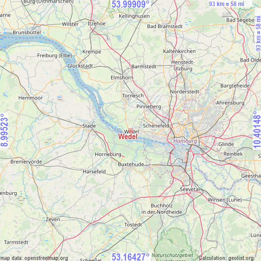
Wedel GPS coordinates[2]
53° 35' 1.464" North, 9° 41' 54.06" East
| Map corner | latitude | longitude |
|---|---|---|
| Upper-left | 53.99909°, | 8.99523° |
| Center: | 53.58374°, | 9.69835° |
| Lower-right: | 53.16427°, | 10.40148° |
| Map W x H: | 92.8×92.8 km | = 57.7×57.7mi |
| max Lat: | 55.01917° ⇑13.2% North |
| Wedel: | 53.58374° |
| min Lat: | ⇓86.8% South 47.40724° |
| min Long | Wedel | max Long |
| 5.92978° | 9.69835° | 14.98853° |
| W 45.6%⇐ | ⇒54.4% E |
Elevation
Elevation of Wedel is 11 m = 36 ft, and this is 238.1 m = 781 ft below average elevation for this country.
| Max E: |
1256 m = 4121 ft | 93.9% |
| Avg. | 249.1 m = 817 ft | |
| Wedel | 11 m = 36 ft | |
Min E: |
-5 m = -16 ft | 6.1% |
See also: Germany elevation on elevation.city.
Geographical zone
Wedel is located in North temperate zone (between Tropic of Cancer and the Arctic Circle). Distance of this North polar circle is 1443.2 km =896.8 mi to North.| Distance of | km | miles | from Wedel |
|---|---|---|---|
| North Pole | 4049.1 | 2516 | to North |
| Arctic Circle | 1443.2 | 896.8 | to North |
| Tropic Cancer | 3352 | 2082.8 | to South |
| Equator | 5958 | 3702.1 | to South |


Nearby cities:
15 places around Wedel: (largest is in red/bold)
• Appen
8.8 km =5.5 mi,  20°
20°
• Grünendeich
5.9 km =3.7 mi,  254°
254°
• Guderhandviertel
7 km =4.3 mi,  236°
236°
• Haselau
10.1 km =6.3 mi,  329°
329°
• Haseldorf
9.3 km =5.8 mi,  310°
310°
• Heist
8 km =5 mi,  336°
336°
• Hetlingen
4.8 km =3 mi,  302°
302°
• Holm
4.2 km =2.6 mi, 330°
• Jork
5.9 km =3.7 mi,  191°
191°
• Mittelnkirchen
6.8 km =4.2 mi,  227°
227°
• Moorrege
9.5 km =5.9 mi,  347°
347°
• Neuenkirchen
9.9 km =6.2 mi,  221°
221°
• Pinneberg
11.1 km =6.9 mi,  32°
32°
• Rellingen
10.7 km =6.6 mi,  46°
46°
• Steinkirchen
6.1 km =3.8 mi, 251°
Sources, notices
• [Note1] Compared only with cities in Germany existing in our database
• [Src1] Map data: © OpenStreetMap contributors (CC-BY-SA)
• [Src2] Other city data from geonames.org with taken over terms of usage.
• [Src3] Geographical zone / Annual Mean Temperature by Robert A. Rohde @ Wikipedia
