Wandersleben geodata
Wandersleben (Thuringia) is a populated place; located in Germany in Europe/Berlin (GMT+2) time zone. With population of 1,716 people, there are 5486 cities with bigger population in this country. Compared to other cities in Germany, 56% of cities are located further ↓South; 64.7% of cities are located further ←West and 55.9% of cities have lower elevation than Wandersleben. Note1


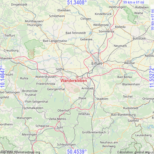
Wandersleben GPS coordinates[2]
50° 53' 58.056" North, 10° 50' 58.524" East
| Map corner | latitude | longitude |
|---|---|---|
| Upper-left | 51.3408°, | 10.14647° |
| Center: | 50.89946°, | 10.84959° |
| Lower-right: | 50.4539°, | 11.55272° |
| Map W x H: | 98.6×98.6 km | = 61.3×61.3mi |
| max Lat: | 55.01917° ⇑44% North |
| Wandersleben: | 50.89946° |
| min Lat: | ⇓56% South 47.40724° |
| min Long | Wandersleben | max Long |
| 5.92978° | 10.84959° | 14.98853° |
| W 64.7%⇐ | ⇒35.3% E |
Elevation
Elevation of Wandersleben is 265 m = 869 ft, and this is 15.9 m = 52 ft above average elevation for this country.
| Max E: |
1256 m = 4121 ft | 44.1% |
| Wandersleben | 265 m 869 ft | |
| Avg. | 249.1 m = 817 ft | |
Min E: |
-5 m = -16 ft | 55.9% |
See also: Germany elevation on elevation.city.
Geographical zone
Wandersleben is located in North temperate zone (between Tropic of Cancer and the Arctic Circle). Distance of this North polar circle is 1741.7 km =1082.2 mi to North.| Distance of | km | miles | from Wandersleben |
|---|---|---|---|
| North Pole | 4347.6 | 2701.5 | to North |
| Arctic Circle | 1741.7 | 1082.2 | to North |
| Tropic Cancer | 3053.6 | 1897.4 | to South |
| Equator | 5659.5 | 3516.6 | to South |


Nearby cities:
15 places around Wandersleben: (largest is in red/bold)
• Apfelstädt
2.8 km =1.7 mi,  85°
85°
• Arnstadt
9.7 km =6 mi,  132°
132°
• Emleben
10.3 km =6.4 mi,  266°
266°
• Friemar
9.6 km =6 mi,  333°
333°
• Gamstädt
6 km =3.7 mi,  24°
24°
• Grabsleben
4.2 km =2.6 mi,  346°
346°
• Ichtershausen
8.9 km =5.5 mi,  107°
107°
• Ingersleben
6.6 km =4.1 mi,  67°
67°
• Neudietendorf
4.7 km =2.9 mi, 72°
• Nottleben
7.5 km =4.7 mi,  0°
0°
• Pferdingsleben
7.8 km =4.8 mi,  342°
342°
• Schwabhausen
8.4 km =5.2 mi,  261°
261°
• Seebergen
4.3 km =2.7 mi,  303°
303°
• Tüttleben
6.7 km =4.2 mi,  319°
319°
• Zimmernsupra
9.4 km =5.8 mi,  7°
7°
Sources, notices
• [Note1] Compared only with cities in Germany existing in our database
• [Src1] Map data: © OpenStreetMap contributors (CC-BY-SA)
• [Src2] Other city data from geonames.org with taken over terms of usage.
• [Src3] Geographical zone / Annual Mean Temperature by Robert A. Rohde @ Wikipedia
