Ingersleben geodata
Ingersleben (Thuringia) is a populated place; located in Germany in Europe/Berlin (GMT+2) time zone. With population of 1,065 people, there are 6948 cities with bigger population in this country. Compared to other cities in Germany, 56.6% of cities are located further ↓South; 66.1% of cities are located further ←West and 50.9% of cities have lower elevation than Ingersleben. Note1


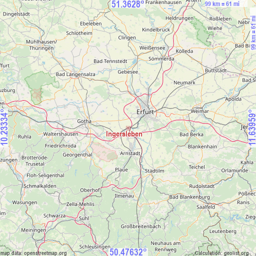
Ingersleben GPS coordinates[2]
50° 55' 18.012" North, 10° 56' 11.256" East
| Map corner | latitude | longitude |
|---|---|---|
| Upper-left | 51.3628°, | 10.23334° |
| Center: | 50.92167°, | 10.93646° |
| Lower-right: | 50.47632°, | 11.63959° |
| Map W x H: | 98.6×98.6 km | = 61.3×61.3mi |
| max Lat: | 55.01917° ⇑43.4% North |
| Ingersleben: | 50.92167° |
| min Lat: | ⇓56.6% South 47.40724° |
| min Long | Ingersleben | max Long |
| 5.92978° | 10.93646° | 14.98853° |
| W 66.1%⇐ | ⇒33.9% E |
Elevation
Elevation of Ingersleben is 232 m = 761 ft, and this is 17.1 m = 56 ft below average elevation for this country.
| Max E: |
1256 m = 4121 ft | 49.1% |
| Avg. | 249.1 m = 817 ft | |
| Ingersleben | 232 m = 761 ft | |
Min E: |
-5 m = -16 ft | 50.9% |
See also: Germany elevation on elevation.city.
Geographical zone
Ingersleben is located in North temperate zone (between Tropic of Cancer and the Arctic Circle). Distance of this North polar circle is 1739.2 km =1080.7 mi to North.| Distance of | km | miles | from Ingersleben |
|---|---|---|---|
| North Pole | 4345.1 | 2699.9 | to North |
| Arctic Circle | 1739.2 | 1080.7 | to North |
| Tropic Cancer | 3056 | 1898.9 | to South |
| Equator | 5662 | 3518.2 | to South |


Nearby cities:
15 places around Ingersleben: (largest is in red/bold)
• Apfelstädt
4 km =2.5 mi,  235°
235°
• Arnstadt
9.1 km =5.7 mi,  173°
173°
• Erfurt
9.3 km =5.8 mi,  46°
46°
• Gamstädt
4.7 km =2.9 mi,  310°
310°
• Grabsleben
7.3 km =4.5 mi,  282°
282°
• Hochheim
6 km =3.7 mi, 46°
• Ichtershausen
5.6 km =3.5 mi,  154°
154°
• Kirchheim
7.1 km =4.4 mi,  127°
127°
• Neudietendorf
1.9 km =1.2 mi, 237°
• Nottleben
7.9 km =4.9 mi, 309°
• Pferdingsleben
9.8 km =6.1 mi,  300°
300°
• Rockhausen
7.6 km =4.7 mi,  107°
107°
• Seebergen
9.6 km =6 mi,  269°
269°
• Wandersleben
6.6 km =4.1 mi,  247°
247°
• Zimmernsupra
8.4 km =5.2 mi,  324°
324°
Sources, notices
• [Note1] Compared only with cities in Germany existing in our database
• [Src1] Map data: © OpenStreetMap contributors (CC-BY-SA)
• [Src2] Other city data from geonames.org with taken over terms of usage.
• [Src3] Geographical zone / Annual Mean Temperature by Robert A. Rohde @ Wikipedia
