Schwabhausen geodata
Schwabhausen (Thuringia) is a seat of a fourth-order administrative division; located in Germany in Europe/Berlin (GMT+2) time zone. With population of 685 people, there are 8387 cities with bigger population in this country. Compared to other cities in Germany, 55.9% of cities are located further ↓South; 63% of cities are located further ←West and 66.8% of cities have lower elevation than Schwabhausen. Note1


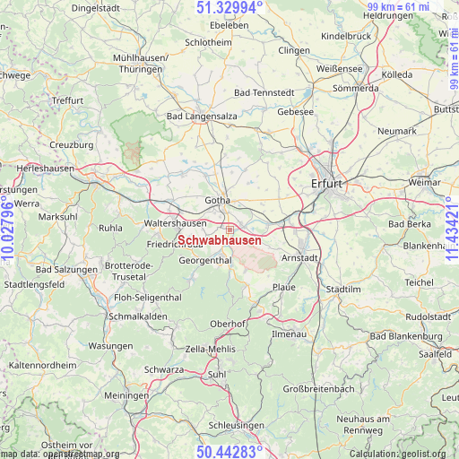
Schwabhausen GPS coordinates[2]
50° 53' 18.6" North, 10° 43' 51.888" East
| Map corner | latitude | longitude |
|---|---|---|
| Upper-left | 51.32994°, | 10.02796° |
| Center: | 50.8885°, | 10.73108° |
| Lower-right: | 50.44283°, | 11.43421° |
| Map W x H: | 98.6×98.6 km | = 61.3×61.3mi |
| max Lat: | 55.01917° ⇑44.1% North |
| Schwabhausen: | 50.8885° |
| min Lat: | ⇓55.9% South 47.40724° |
| min Long | Schwabhausen | max Long |
| 5.92978° | 10.73108° | 14.98853° |
| W 63%⇐ | ⇒37% E |
Elevation
Elevation of Schwabhausen is 334 m = 1096 ft, and this is 84.9 m = 279 ft above average elevation for this country.
| Max E: |
1256 m = 4121 ft | 33.2% |
| Schwabhausen | 334 m 1096 ft | |
| Avg. | 249.1 m = 817 ft | |
Min E: |
-5 m = -16 ft | 66.8% |
See also: Germany elevation on elevation.city.
Geographical zone
Schwabhausen is located in North temperate zone (between Tropic of Cancer and the Arctic Circle). Distance of this North polar circle is 1742.9 km =1083 mi to North.| Distance of | km | miles | from Schwabhausen |
|---|---|---|---|
| North Pole | 4348.8 | 2702.2 | to North |
| Arctic Circle | 1742.9 | 1083 | to North |
| Tropic Cancer | 3052.4 | 1896.7 | to South |
| Equator | 5658.3 | 3515.9 | to South |


Nearby cities:
15 places around Schwabhausen: (largest is in red/bold)
• Emleben
2.1 km =1.3 mi,  287°
287°
• Ernstroda
8.2 km =5.1 mi,  251°
251°
• Friemar
10.6 km =6.6 mi,  22°
22°
• Georgenthal
7.9 km =4.9 mi,  217°
217°
• Gotha
6.9 km =4.3 mi,  342°
342°
• Grabsleben
9 km =5.6 mi,  53°
53°
• Gräfenhain
8.3 km =5.2 mi,  195°
195°
• Herrenhof
6 km =3.7 mi,  210°
210°
• Hohenkirchen
4.8 km =3 mi, 206°
• Petriroda
3.3 km =2.1 mi, 221°
• Remstädt
10.5 km =6.5 mi, 343°
• Seebergen
6 km =3.7 mi, 53°
• Tüttleben
7.5 km =4.7 mi,  31°
31°
• Wandersleben
8.4 km =5.2 mi,  81°
81°
• Wölfis
9.5 km =5.9 mi,  159°
159°
Sources, notices
• [Note1] Compared only with cities in Germany existing in our database
• [Src1] Map data: © OpenStreetMap contributors (CC-BY-SA)
• [Src2] Other city data from geonames.org with taken over terms of usage.
• [Src3] Geographical zone / Annual Mean Temperature by Robert A. Rohde @ Wikipedia
