Walternienburg geodata
Walternienburg (Saxony-Anhalt) is a populated place; located in Germany in Europe/Berlin (GMT+2) time zone. With population of 547 people, there are 9098 cities with bigger population in this country. Compared to other cities in Germany, 71.8% of cities are located further ↓South; 81% of cities are located further ←West and 77% of cities have higher elevation than Walternienburg. Note1


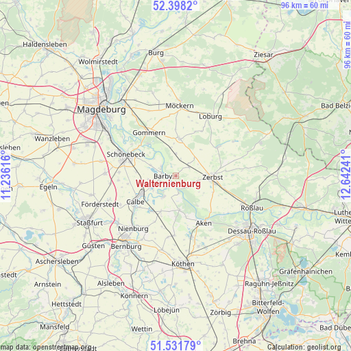
Walternienburg GPS coordinates[2]
51° 58' 1.524" North, 11° 56' 21.408" East
| Map corner | latitude | longitude |
|---|---|---|
| Upper-left | 52.3982°, | 11.23616° |
| Center: | 51.96709°, | 11.93928° |
| Lower-right: | 51.53179°, | 12.64241° |
| Map W x H: | 96.3×96.3 km | = 59.8×59.8mi |
| max Lat: | 55.01917° ⇑28.2% North |
| Walternienburg: | 51.96709° |
| min Lat: | ⇓71.8% South 47.40724° |
| min Long | Walternienburg | max Long |
| 5.92978° | 11.93928° | 14.98853° |
| W 81%⇐ | ⇒19% E |
Elevation
Elevation of Walternienburg is 56 m = 184 ft, and this is 193.1 m = 634 ft below average elevation for this country.
| Max E: |
1256 m = 4121 ft | 77% |
| Avg. | 249.1 m = 817 ft | |
| Walternienburg | 56 m = 184 ft | |
Min E: |
-5 m = -16 ft | 23% |
See also: Germany elevation on elevation.city.
Geographical zone
Walternienburg is located in North temperate zone (between Tropic of Cancer and the Arctic Circle). Distance of this North polar circle is 1623 km =1008.5 mi to North.| Distance of | km | miles | from Walternienburg |
|---|---|---|---|
| North Pole | 4228.9 | 2627.7 | to North |
| Arctic Circle | 1623 | 1008.5 | to North |
| Tropic Cancer | 3172.3 | 1971.2 | to South |
| Equator | 5778.2 | 3590.4 | to South |


Nearby cities:
15 places around Walternienburg: (largest is in red/bold)
• Barby
3.9 km =2.4 mi,  270°
270°
• Breitenhagen
4.9 km =3 mi,  172°
172°
• Calbe
13.1 km =8.1 mi,  239°
239°
• Dannigkow
12.3 km =7.6 mi,  338°
338°
• Gnadau
11 km =6.8 mi,  275°
275°
• Groß Rosenburg
6.5 km =4 mi,  210°
210°
• Güterglück
4.3 km =2.7 mi,  56°
56°
• Jütrichau
13.5 km =8.4 mi,  104°
104°
• Klein Mühlingen
13.5 km =8.4 mi,  260°
260°
• Leitzkau
10.2 km =6.3 mi,  4°
4°
• Plötzky
13.3 km =8.3 mi,  315°
315°
• Pretzien
11.6 km =7.2 mi, 318°
• Pömmelte
7.7 km =4.8 mi,  293°
293°
• Tornitz
7.5 km =4.7 mi, 236°
• Zerbst
10 km =6.2 mi,  90°
90°
Sources, notices
• [Note1] Compared only with cities in Germany existing in our database
• [Src1] Map data: © OpenStreetMap contributors (CC-BY-SA)
• [Src2] Other city data from geonames.org with taken over terms of usage.
• [Src3] Geographical zone / Annual Mean Temperature by Robert A. Rohde @ Wikipedia
