Dannigkow geodata
Dannigkow (Saxony-Anhalt) is a populated place; located in Germany in Europe/Berlin (GMT+2) time zone. With population of 698 people, there are 8324 cities with bigger population in this country. Compared to other cities in Germany, 72.7% of cities are located further ↓South; 79.9% of cities are located further ←West and 77.9% of cities have higher elevation than Dannigkow. Note1


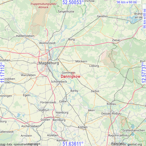
Dannigkow GPS coordinates[2]
52° 4' 13.476" North, 11° 52' 27.264" East
| Map corner | latitude | longitude |
|---|---|---|
| Upper-left | 52.50053°, | 11.17112° |
| Center: | 52.07041°, | 11.87424° |
| Lower-right: | 51.63611°, | 12.57737° |
| Map W x H: | 96.1×96.1 km | = 59.7×59.7mi |
| max Lat: | 55.01917° ⇑27.3% North |
| Dannigkow: | 52.07041° |
| min Lat: | ⇓72.7% South 47.40724° |
| min Long | Dannigkow | max Long |
| 5.92978° | 11.87424° | 14.98853° |
| W 79.9%⇐ | ⇒20.1% E |
Elevation
Elevation of Dannigkow is 53 m = 174 ft, and this is 196.1 m = 643 ft below average elevation for this country.
| Max E: |
1256 m = 4121 ft | 77.9% |
| Avg. | 249.1 m = 817 ft | |
| Dannigkow | 53 m = 174 ft | |
Min E: |
-5 m = -16 ft | 22.1% |
See also: Germany elevation on elevation.city.
Geographical zone
Dannigkow is located in North temperate zone (between Tropic of Cancer and the Arctic Circle). Distance of this North polar circle is 1611.5 km =1001.3 mi to North.| Distance of | km | miles | from Dannigkow |
|---|---|---|---|
| North Pole | 4217.4 | 2620.6 | to North |
| Arctic Circle | 1611.5 | 1001.3 | to North |
| Tropic Cancer | 3183.8 | 1978.3 | to South |
| Equator | 5789.7 | 3597.6 | to South |


Nearby cities:
15 places around Dannigkow: (largest is in red/bold)
• Barby
11.5 km =7.1 mi,  177°
177°
• Gommern
3.5 km =2.2 mi,  276°
276°
• Güterglück
12.1 km =7.5 mi,  138°
138°
• Königsborn
11.1 km =6.9 mi,  312°
312°
• Leitzkau
5.5 km =3.4 mi,  104°
104°
• Menz
9.3 km =5.8 mi, 305°
• Möckern
9.5 km =5.9 mi,  34°
34°
• Nedlitz
7 km =4.3 mi,  335°
335°
• Plötzky
5.3 km =3.3 mi,  247°
247°
• Pretzien
4.3 km =2.7 mi,  229°
229°
• Pömmelte
8.9 km =5.5 mi,  197°
197°
• Schönebeck
11.5 km =7.1 mi,  238°
238°
• Wahlitz
7.5 km =4.7 mi,  299°
299°
• Walternienburg
12.3 km =7.6 mi,  158°
158°
• Zeppernick
11.8 km =7.3 mi,  58°
58°
Sources, notices
• [Note1] Compared only with cities in Germany existing in our database
• [Src1] Map data: © OpenStreetMap contributors (CC-BY-SA)
• [Src2] Other city data from geonames.org with taken over terms of usage.
• [Src3] Geographical zone / Annual Mean Temperature by Robert A. Rohde @ Wikipedia
