Tornitz geodata
Tornitz (Saxony-Anhalt) is a populated place; located in Germany in Europe/Berlin (GMT+2) time zone. With population of 620 people, there are 8720 cities with bigger population in this country. Compared to other cities in Germany, 71.4% of cities are located further ↓South; 79.4% of cities are located further ←West and 77.5% of cities have higher elevation than Tornitz. Note1


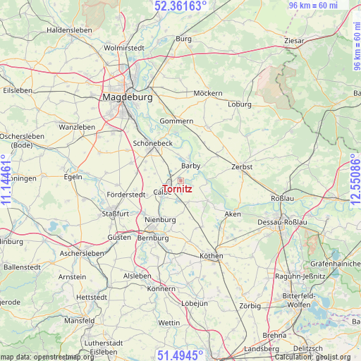
Tornitz GPS coordinates[2]
51° 55' 48.576" North, 11° 50' 51.828" East
| Map corner | latitude | longitude |
|---|---|---|
| Upper-left | 52.36163°, | 11.14461° |
| Center: | 51.93016°, | 11.84773° |
| Lower-right: | 51.4945°, | 12.55086° |
| Map W x H: | 96.4×96.4 km | = 59.9×59.9mi |
| max Lat: | 55.01917° ⇑28.6% North |
| Tornitz: | 51.93016° |
| min Lat: | ⇓71.4% South 47.40724° |
| min Long | Tornitz | max Long |
| 5.92978° | 11.84773° | 14.98853° |
| W 79.4%⇐ | ⇒20.6% E |
Elevation
Elevation of Tornitz is 54 m = 177 ft, and this is 195.1 m = 640 ft below average elevation for this country.
| Max E: |
1256 m = 4121 ft | 77.5% |
| Avg. | 249.1 m = 817 ft | |
| Tornitz | 54 m = 177 ft | |
Min E: |
-5 m = -16 ft | 22.5% |
See also: Germany elevation on elevation.city.
Geographical zone
Tornitz is located in North temperate zone (between Tropic of Cancer and the Arctic Circle). Distance of this North polar circle is 1627.1 km =1011 mi to North.| Distance of | km | miles | from Tornitz |
|---|---|---|---|
| North Pole | 4233 | 2630.3 | to North |
| Arctic Circle | 1627.1 | 1011 | to North |
| Tropic Cancer | 3168.2 | 1968.6 | to South |
| Equator | 5774.1 | 3587.9 | to South |


Nearby cities:
15 places around Tornitz: (largest is in red/bold)
• Barby
4.8 km =3 mi,  30°
30°
• Breitenhagen
7 km =4.3 mi,  96°
96°
• Brumby
9.7 km =6 mi,  247°
247°
• Calbe
5.6 km =3.5 mi,  242°
242°
• Eggersdorf
10.8 km =6.7 mi,  298°
298°
• Eickendorf
12 km =7.5 mi,  279°
279°
• Gerbitz
9.9 km =6.2 mi,  188°
188°
• Glöthe
12.1 km =7.5 mi,  259°
259°
• Gnadau
7 km =4.3 mi,  318°
318°
• Groß Rosenburg
3.4 km =2.1 mi,  115°
115°
• Güterglück
11.8 km =7.3 mi,  56°
56°
• Klein Mühlingen
7.3 km =4.5 mi,  285°
285°
• Nienburg/Saale
11.6 km =7.2 mi,  207°
207°
• Pömmelte
7.2 km =4.5 mi,  353°
353°
• Walternienburg
7.5 km =4.7 mi, 56°
Sources, notices
• [Note1] Compared only with cities in Germany existing in our database
• [Src1] Map data: © OpenStreetMap contributors (CC-BY-SA)
• [Src2] Other city data from geonames.org with taken over terms of usage.
• [Src3] Geographical zone / Annual Mean Temperature by Robert A. Rohde @ Wikipedia
