Wallenborn geodata
Wallenborn (Rheinland-Pfalz) is a seat of a fourth-order administrative division; located in Germany in Europe/Berlin (GMT+2) time zone. With population of 493 people, there are 9401 cities with bigger population in this country. Compared to other cities in Germany, 60.2% of cities are located further ↑North; 96.3% of cities are located further →East and 81.3% of cities have lower elevation than Wallenborn. Note1


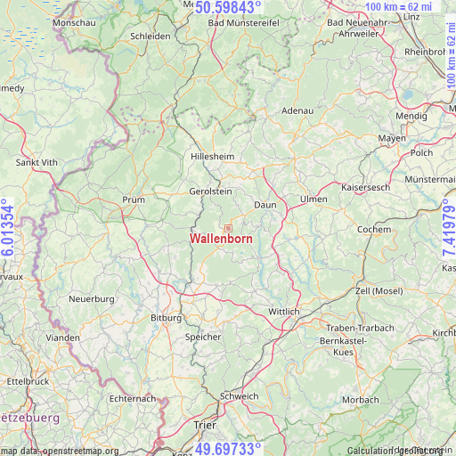
Wallenborn GPS coordinates[2]
50° 9' 0" North, 6° 43' 0.012" East
| Map corner | latitude | longitude |
|---|---|---|
| Upper-left | 50.59843°, | 6.01354° |
| Center: | 50.15°, | 6.71667° |
| Lower-right: | 49.69733°, | 7.41979° |
| Map W x H: | 100.2×100.2 km | = 62.3×62.3mi |
| max Lat: | 55.01917° ⇑60.2% North |
| Wallenborn: | 50.15° |
| min Lat: | ⇓39.8% South 47.40724° |
| min Long | Wallenborn | max Long |
| 5.92978° | 6.71667° | 14.98853° |
| W 3.7%⇐ | ⇒96.3% E |
Elevation
Elevation of Wallenborn is 442 m = 1450 ft, and this is 192.9 m = 633 ft above average elevation for this country.
| Max E: |
1256 m = 4121 ft | 18.7% |
| Wallenborn | 442 m 1450 ft | |
| Avg. | 249.1 m = 817 ft | |
Min E: |
-5 m = -16 ft | 81.3% |
See also: Germany elevation on elevation.city.
Geographical zone
Wallenborn is located in North temperate zone (between Tropic of Cancer and the Arctic Circle). Distance of this North polar circle is 1825 km =1134 mi to North.| Distance of | km | miles | from Wallenborn |
|---|---|---|---|
| North Pole | 4430.9 | 2753.2 | to North |
| Arctic Circle | 1825 | 1134 | to North |
| Tropic Cancer | 2970.2 | 1845.6 | to South |
| Equator | 5576.2 | 3464.9 | to South |


Nearby cities:
15 places around Wallenborn: (largest is in red/bold)
• Bettenfeld
7.9 km =4.9 mi,  156°
156°
• Birresborn
7 km =4.3 mi,  301°
301°
• Bleckhausen
5.1 km =3.2 mi,  111°
111°
• Densborn
8.8 km =5.5 mi,  249°
249°
• Deudesfeld
5.4 km =3.4 mi,  169°
169°
• Meerfeld
6.8 km =4.2 mi, 155°
• Meisburg
4.4 km =2.7 mi,  212°
212°
• Mürlenbach
8.3 km =5.2 mi,  270°
270°
• Neroth
5.6 km =3.5 mi,  22°
22°
• Niederstadtfeld
3.3 km =2.1 mi,  69°
69°
• Oberstadtfeld
4.7 km =2.9 mi,  52°
52°
• Salm
1.9 km =1.2 mi,  279°
279°
• Schutz
3 km =1.9 mi,  127°
127°
• Weidenbach
1.9 km =1.2 mi,  180°
180°
• Üdersdorf
5.9 km =3.7 mi,  90°
90°
Sources, notices
• [Note1] Compared only with cities in Germany existing in our database
• [Src1] Map data: © OpenStreetMap contributors (CC-BY-SA)
• [Src2] Other city data from geonames.org with taken over terms of usage.
• [Src3] Geographical zone / Annual Mean Temperature by Robert A. Rohde @ Wikipedia
