Talheim geodata
Talheim (Baden-Württemberg) is a seat of a fourth-order administrative division; located in Germany in Europe/Berlin (GMT+2) time zone. With population of 4,758 people, there are 2920 cities with bigger population in this country. Compared to other cities in Germany, 82% of cities are located further ↑North; 62.5% of cities are located further →East and 52.9% of cities have higher elevation than Talheim. Note1
Administrative division(s):
- Level 1: Baden-Württemberg
- Level 2: Regierungsbezirk Stuttgart
- Level 3: Landkreis Heilbronn
- Level 4: Talheim


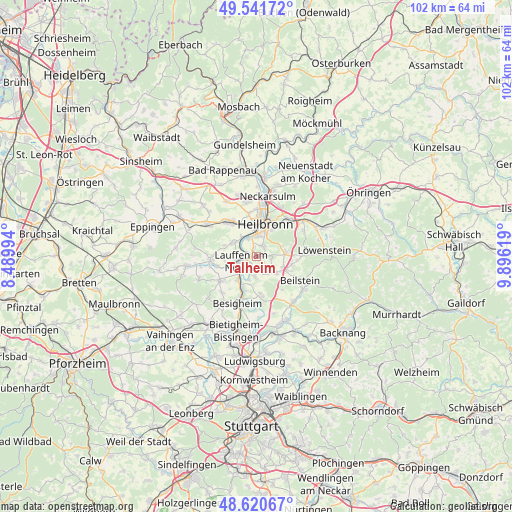
Talheim GPS coordinates[2]
49° 4' 59.988" North, 9° 11' 35.016" East
| Map corner | latitude | longitude |
|---|---|---|
| Upper-left | 49.54172°, | 8.48994° |
| Center: | 49.08333°, | 9.19306° |
| Lower-right: | 48.62067°, | 9.89619° |
| Map W x H: | 102.4×102.4 km | = 63.6×63.6mi |
| max Lat: | 55.01917° ⇑82% North |
| Talheim: | 49.08333° |
| min Lat: | ⇓18% South 47.40724° |
| min Long | Talheim | max Long |
| 5.92978° | 9.19306° | 14.98853° |
| W 37.5%⇐ | ⇒62.5% E |
Elevation
Elevation of Talheim is 205 m = 673 ft, and this is 44.1 m = 145 ft below average elevation for this country.
| Max E: |
1256 m = 4121 ft | 52.9% |
| Avg. | 249.1 m = 817 ft | |
| Talheim | 205 m = 673 ft | |
Min E: |
-5 m = -16 ft | 47.1% |
See also: Germany elevation on elevation.city.
Geographical zone
Talheim is located in North temperate zone (between Tropic of Cancer and the Arctic Circle). Distance of this North polar circle is 1943.6 km =1207.7 mi to North.| Distance of | km | miles | from Talheim |
|---|---|---|---|
| North Pole | 4549.5 | 2826.9 | to North |
| Arctic Circle | 1943.6 | 1207.7 | to North |
| Tropic Cancer | 2851.6 | 1771.9 | to South |
| Equator | 5457.6 | 3391.2 | to South |


Nearby cities:
15 places around Talheim: (largest is in red/bold)
• Abstatt
7.3 km =4.5 mi,  103°
103°
• Brackenheim
9.3 km =5.8 mi,  266°
266°
• Bönnigheim
8.7 km =5.4 mi,  236°
236°
• Flein
2.5 km =1.6 mi,  30°
30°
• Gemmrigheim
6.7 km =4.2 mi,  204°
204°
• Heilbronn
6.6 km =4.1 mi,  17°
17°
• Ilsfeld
4.9 km =3 mi,  128°
128°
• Kirchheim am Neckar
5.6 km =3.5 mi,  220°
220°
• Lauffen am Neckar
3.6 km =2.2 mi,  252°
252°
• Leingarten
8.9 km =5.5 mi,  321°
321°
• Mundelsheim
9.2 km =5.7 mi,  173°
173°
• Neckarwestheim
4.1 km =2.5 mi,  183°
183°
• Nordheim
5.5 km =3.4 mi,  300°
300°
• Untergruppenbach
6 km =3.7 mi,  83°
83°
• Walheim
8.3 km =5.2 mi, 201°
Sources, notices
• [Note1] Compared only with cities in Germany existing in our database
• [Src1] Map data: © OpenStreetMap contributors (CC-BY-SA)
• [Src2] Other city data from geonames.org with taken over terms of usage.
• [Src3] Geographical zone / Annual Mean Temperature by Robert A. Rohde @ Wikipedia
