Neckarwestheim geodata
Neckarwestheim (Baden-Württemberg) is a seat of a fourth-order administrative division; located in Germany in Europe/Berlin (GMT+2) time zone. With population of 3,568 people, there are 3566 cities with bigger population in this country. Compared to other cities in Germany, 82.5% of cities are located further ↑North; 62.5% of cities are located further →East and 54.9% of cities have lower elevation than Neckarwestheim. Note1
Administrative division(s):
- Level 1: Baden-Württemberg
- Level 2: Regierungsbezirk Stuttgart
- Level 3: Landkreis Heilbronn
- Level 4: Neckarwestheim


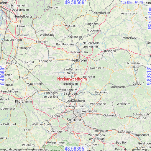
Neckarwestheim GPS coordinates[2]
49° 2' 48.984" North, 9° 11' 24" East
| Map corner | latitude | longitude |
|---|---|---|
| Upper-left | 49.50566°, | 8.48688° |
| Center: | 49.04694°, | 9.19° |
| Lower-right: | 48.58395°, | 9.89313° |
| Map W x H: | 102.5×102.5 km | = 63.7×63.7mi |
| max Lat: | 55.01917° ⇑82.5% North |
| Neckarwestheim: | 49.04694° |
| min Lat: | ⇓17.5% South 47.40724° |
| min Long | Neckarwestheim | max Long |
| 5.92978° | 9.19° | 14.98853° |
| W 37.5%⇐ | ⇒62.5% E |
Elevation
Elevation of Neckarwestheim is 257 m = 843 ft, and this is 7.9 m = 26 ft above average elevation for this country.
| Max E: |
1256 m = 4121 ft | 45.1% |
| Neckarwestheim | 257 m 843 ft | |
| Avg. | 249.1 m = 817 ft | |
Min E: |
-5 m = -16 ft | 54.9% |
See also: Germany elevation on elevation.city.
Geographical zone
Neckarwestheim is located in North temperate zone (between Tropic of Cancer and the Arctic Circle). Distance of this North polar circle is 1947.7 km =1210.2 mi to North.| Distance of | km | miles | from Neckarwestheim |
|---|---|---|---|
| North Pole | 4553.6 | 2829.5 | to North |
| Arctic Circle | 1947.7 | 1210.2 | to North |
| Tropic Cancer | 2847.6 | 1769.4 | to South |
| Equator | 5453.5 | 3388.6 | to South |


Nearby cities:
15 places around Neckarwestheim: (largest is in red/bold)
• Abstatt
7.7 km =4.8 mi,  72°
72°
• Besigheim
6.4 km =4 mi,  212°
212°
• Bönnigheim
7 km =4.3 mi,  263°
263°
• Erligheim
7.3 km =4.5 mi,  248°
248°
• Flein
6.4 km =4 mi,  13°
13°
• Gemmrigheim
3.3 km =2.1 mi,  230°
230°
• Hessigheim
5.9 km =3.7 mi,  182°
182°
• Ilsfeld
4.2 km =2.6 mi,  76°
76°
• Kirchheim am Neckar
3.5 km =2.2 mi,  266°
266°
• Lauffen am Neckar
4.4 km =2.7 mi,  312°
312°
• Löchgau
7.8 km =4.8 mi, 231°
• Mundelsheim
5.3 km =3.3 mi,  165°
165°
• Talheim
4.1 km =2.5 mi,  3°
3°
• Untergruppenbach
7.8 km =4.8 mi,  52°
52°
• Walheim
4.6 km =2.9 mi,  217°
217°
Sources, notices
• [Note1] Compared only with cities in Germany existing in our database
• [Src1] Map data: © OpenStreetMap contributors (CC-BY-SA)
• [Src2] Other city data from geonames.org with taken over terms of usage.
• [Src3] Geographical zone / Annual Mean Temperature by Robert A. Rohde @ Wikipedia
