Lauffen am Neckar geodata
Lauffen am Neckar (Baden-Württemberg) is a populated place; located in Germany in Europe/Berlin (GMT+2) time zone. With population of 11,068 people, there are 1493 cities with bigger population in this country. Compared to other cities in Germany, 82.1% of cities are located further ↑North; 63.3% of cities are located further →East and 55.4% of cities have higher elevation than Lauffen am Neckar. Note1
Administrative division(s):
- Level 1: Baden-Württemberg
- Level 2: Regierungsbezirk Stuttgart
- Level 3: Landkreis Heilbronn
- Level 4: Lauffen am Neckar


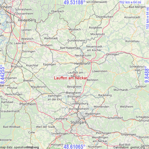
Lauffen am Neckar GPS coordinates[2]
49° 4' 24.24" North, 9° 8' 44.412" East
| Map corner | latitude | longitude |
|---|---|---|
| Upper-left | 49.53188°, | 8.44255° |
| Center: | 49.0734°, | 9.14567° |
| Lower-right: | 48.61065°, | 9.8488° |
| Map W x H: | 102.4×102.4 km | = 63.6×63.6mi |
| max Lat: | 55.01917° ⇑82.1% North |
| Lauffen am Neckar: | 49.0734° |
| min Lat: | ⇓17.9% South 47.40724° |
| min Long | Lauffen am Neck | max Long |
| 5.92978° | 9.14567° | 14.98853° |
| W 36.7%⇐ | ⇒63.3% E |
Elevation
Elevation of Lauffen am Neckar is 186 m = 610 ft, and this is 63.1 m = 207 ft below average elevation for this country.
| Max E: |
1256 m = 4121 ft | 55.4% |
| Avg. | 249.1 m = 817 ft | |
| Lauffen am Neckar | 186 m = 610 ft | |
Min E: |
-5 m = -16 ft | 44.6% |
See also: Germany elevation on elevation.city.
Geographical zone
Lauffen am Neckar is located in North temperate zone (between Tropic of Cancer and the Arctic Circle). Distance of this North polar circle is 1944.7 km =1208.4 mi to North.| Distance of | km | miles | from Lauffen am Neckar |
|---|---|---|---|
| North Pole | 4550.6 | 2827.6 | to North |
| Arctic Circle | 1944.7 | 1208.4 | to North |
| Tropic Cancer | 2850.5 | 1771.2 | to South |
| Equator | 5456.5 | 3390.5 | to South |


Nearby cities:
15 places around Lauffen am Neckar: (largest is in red/bold)
• Besigheim
8.4 km =5.2 mi,  181°
181°
• Brackenheim
5.8 km =3.6 mi,  274°
274°
• Bönnigheim
5.3 km =3.3 mi,  225°
225°
• Cleebronn
8.5 km =5.3 mi,  248°
248°
• Erligheim
6.7 km =4.2 mi,  211°
211°
• Flein
5.8 km =3.6 mi,  55°
55°
• Gemmrigheim
5.1 km =3.2 mi,  171°
171°
• Ilsfeld
7.6 km =4.7 mi,  105°
105°
• Kirchheim am Neckar
3.2 km =2 mi, 184°
• Leingarten
8.4 km =5.2 mi,  345°
345°
• Löchgau
8.3 km =5.2 mi,  200°
200°
• Neckarwestheim
4.4 km =2.7 mi,  132°
132°
• Nordheim
4.1 km =2.5 mi,  341°
341°
• Talheim
3.6 km =2.2 mi,  72°
72°
• Walheim
6.6 km =4.1 mi, 176°
Sources, notices
• [Note1] Compared only with cities in Germany existing in our database
• [Src1] Map data: © OpenStreetMap contributors (CC-BY-SA)
• [Src2] Other city data from geonames.org with taken over terms of usage.
• [Src3] Geographical zone / Annual Mean Temperature by Robert A. Rohde @ Wikipedia
