Waldmünchen geodata
Waldmünchen (Bavaria) is a populated place; located in Germany in Europe/Berlin (GMT+2) time zone. With population of 7,392 people, there are 2094 cities with bigger population in this country. Compared to other cities in Germany, 77.5% of cities are located further ↑North; 89.9% of cities are located further ←West and 90.9% of cities have lower elevation than Waldmünchen. Note1
Administrative division(s):
- Level 1: Bavaria
- Level 2: Upper Palatinate
- Level 3: Landkreis Cham
- Level 4: Waldmünchen


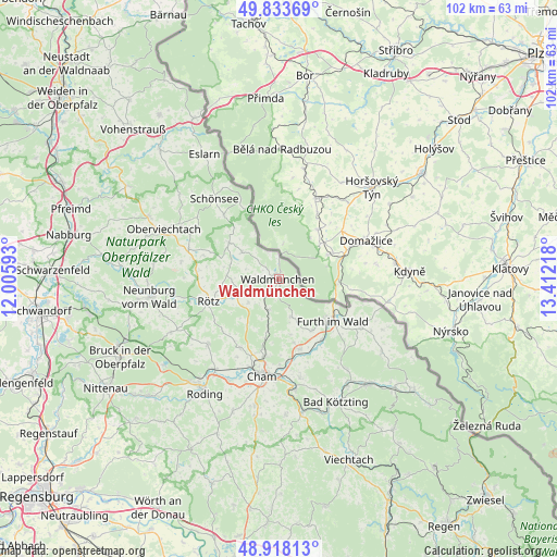
Waldmünchen GPS coordinates[2]
49° 22' 40.944" North, 12° 42' 32.58" East
| Map corner | latitude | longitude |
|---|---|---|
| Upper-left | 49.83369°, | 12.00593° |
| Center: | 49.37804°, | 12.70905° |
| Lower-right: | 48.91813°, | 13.41218° |
| Map W x H: | 101.8×101.8 km | = 63.3×63.3mi |
| max Lat: | 55.01917° ⇑77.5% North |
| Waldmünchen: | 49.37804° |
| min Lat: | ⇓22.5% South 47.40724° |
| min Long | Waldmünchen | max Long |
| 5.92978° | 12.70905° | 14.98853° |
| W 89.9%⇐ | ⇒10.1% E |
Elevation
Elevation of Waldmünchen is 526 m = 1726 ft, and this is 276.9 m = 908 ft above average elevation for this country.
| Max E: |
1256 m = 4121 ft | 9.1% |
| Waldmünchen | 526 m 1726 ft | |
| Avg. | 249.1 m = 817 ft | |
Min E: |
-5 m = -16 ft | 90.9% |
See also: Germany elevation on elevation.city.
Geographical zone
Waldmünchen is located in North temperate zone (between Tropic of Cancer and the Arctic Circle). Distance of this North polar circle is 1910.9 km =1187.4 mi to North.| Distance of | km | miles | from Waldmünchen |
|---|---|---|---|
| North Pole | 4516.7 | 2806.5 | to North |
| Arctic Circle | 1910.9 | 1187.4 | to North |
| Tropic Cancer | 2884.4 | 1792.3 | to South |
| Equator | 5490.3 | 3411.5 | to South |


Nearby cities:
15 places around Waldmünchen: (largest is in red/bold)
• Arnschwang
13.7 km =8.5 mi,  145°
145°
• Cham
17.4 km =10.8 mi,  193°
193°
• Eschlkam
17.4 km =10.8 mi,  120°
120°
• Furth im Wald
12.3 km =7.6 mi,  128°
128°
• Gleißenberg
7 km =4.3 mi,  165°
165°
• Pemfling
14.1 km =8.8 mi,  208°
208°
• Rötz
13.6 km =8.5 mi,  253°
253°
• Schönthal
8.5 km =5.3 mi, 248°
• Stadlern
15.9 km =9.9 mi,  333°
333°
• Tiefenbach
11 km =6.8 mi,  304°
304°
• Treffelstein
8.4 km =5.2 mi,  306°
306°
• Waffenbrunn
12.8 km =8 mi, 193°
• Weiding
13.4 km =8.3 mi,  162°
162°
• Weiding
15.6 km =9.7 mi,  318°
318°
• Willmering
14.6 km =9.1 mi, 192°
Sources, notices
• [Note1] Compared only with cities in Germany existing in our database
• [Src1] Map data: © OpenStreetMap contributors (CC-BY-SA)
• [Src2] Other city data from geonames.org with taken over terms of usage.
• [Src3] Geographical zone / Annual Mean Temperature by Robert A. Rohde @ Wikipedia
