Furth im Wald geodata
Furth im Wald (Bavaria) is a populated place; located in Germany in Europe/Berlin (GMT+2) time zone. With population of 9,480 people, there are 1708 cities with bigger population in this country. Compared to other cities in Germany, 78.5% of cities are located further ↑North; 91.1% of cities are located further ←West and 75.7% of cities have lower elevation than Furth im Wald. Note1
Administrative division(s):
- Level 1: Bavaria
- Level 2: Upper Palatinate
- Level 3: Landkreis Cham
- Level 4: Furth im Wald


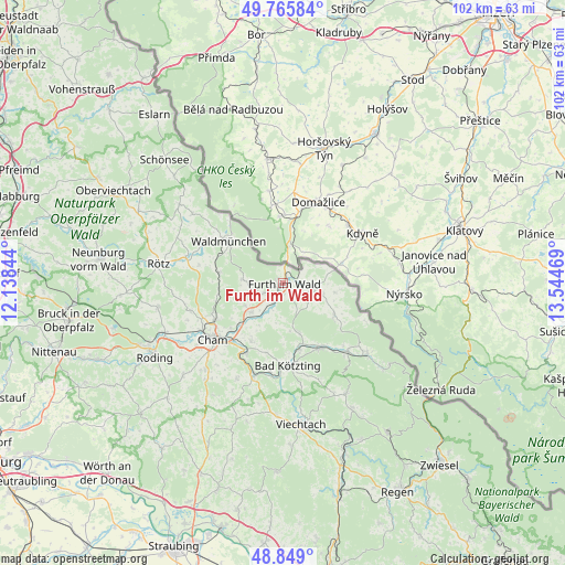
Furth im Wald GPS coordinates[2]
49° 18' 34.38" North, 12° 50' 29.616" East
| Map corner | latitude | longitude |
|---|---|---|
| Upper-left | 49.76584°, | 12.13844° |
| Center: | 49.30955°, | 12.84156° |
| Lower-right: | 48.849°, | 13.54469° |
| Map W x H: | 101.9×101.9 km | = 63.3×63.3mi |
| max Lat: | 55.01917° ⇑78.5% North |
| Furth im Wald: | 49.30955° |
| min Lat: | ⇓21.5% South 47.40724° |
| min Long | Furth im Wald | max Long |
| 5.92978° | 12.84156° | 14.98853° |
| W 91.1%⇐ | ⇒8.9% E |
Elevation
Elevation of Furth im Wald is 403 m = 1322 ft, and this is 153.9 m = 505 ft above average elevation for this country.
| Max E: |
1256 m = 4121 ft | 24.3% |
| Furth im Wald | 403 m 1322 ft | |
| Avg. | 249.1 m = 817 ft | |
Min E: |
-5 m = -16 ft | 75.7% |
See also: Germany elevation on elevation.city.
Geographical zone
Furth im Wald is located in North temperate zone (between Tropic of Cancer and the Arctic Circle). Distance of this North polar circle is 1918.5 km =1192.1 mi to North.| Distance of | km | miles | from Furth im Wald |
|---|---|---|---|
| North Pole | 4524.4 | 2811.3 | to North |
| Arctic Circle | 1918.5 | 1192.1 | to North |
| Tropic Cancer | 2876.8 | 1787.6 | to South |
| Equator | 5482.7 | 3406.8 | to South |


Nearby cities:
15 places around Furth im Wald: (largest is in red/bold)
• Arnschwang
4.1 km =2.5 mi,  206°
206°
• Blaibach
16 km =9.9 mi,  186°
186°
• Chamerau
13.9 km =8.6 mi, 208°
• Eschlkam
5.5 km =3.4 mi,  102°
102°
• Gleißenberg
7.9 km =4.9 mi,  275°
275°
• Grafenwiesen
12.6 km =7.8 mi,  166°
166°
• Hohenwarth
13.9 km =8.6 mi,  151°
151°
• Kötzting
14.8 km =9.2 mi,  176°
176°
• Neukirchen
10.8 km =6.7 mi,  120°
120°
• Rimbach
9 km =5.6 mi,  160°
160°
• Runding
12 km =7.5 mi, 208°
• Waffenbrunn
13.6 km =8.5 mi,  249°
249°
• Waldmünchen
12.3 km =7.6 mi,  308°
308°
• Weiding
7.7 km =4.8 mi,  227°
227°
• Willmering
14.3 km =8.9 mi,  242°
242°
Sources, notices
• [Note1] Compared only with cities in Germany existing in our database
• [Src1] Map data: © OpenStreetMap contributors (CC-BY-SA)
• [Src2] Other city data from geonames.org with taken over terms of usage.
• [Src3] Geographical zone / Annual Mean Temperature by Robert A. Rohde @ Wikipedia
