Rötz geodata
Rötz (Bavaria) is a populated place; located in Germany in Europe/Berlin (GMT+2) time zone. With population of 3,548 people, there are 3577 cities with bigger population in this country. Compared to other cities in Germany, 78% of cities are located further ↑North; 88.2% of cities are located further ←West and 83.9% of cities have lower elevation than Rötz. Note1
Administrative division(s):
- Level 1: Bavaria
- Level 2: Upper Palatinate
- Level 3: Landkreis Cham
- Level 4: Rötz


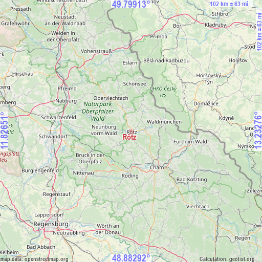
Rötz GPS coordinates[2]
49° 20' 35.376" North, 12° 31' 46.668" East
| Map corner | latitude | longitude |
|---|---|---|
| Upper-left | 49.79913°, | 11.82651° |
| Center: | 49.34316°, | 12.52963° |
| Lower-right: | 48.88292°, | 13.23276° |
| Map W x H: | 101.9×101.9 km | = 63.3×63.3mi |
| max Lat: | 55.01917° ⇑78% North |
| Rötz: | 49.34316° |
| min Lat: | ⇓22% South 47.40724° |
| min Long | Rötz | max Long |
| 5.92978° | 12.52963° | 14.98853° |
| W 88.2%⇐ | ⇒11.8% E |
Elevation
Elevation of Rötz is 461 m = 1512 ft, and this is 211.9 m = 695 ft above average elevation for this country.
| Max E: |
1256 m = 4121 ft | 16.1% |
| Rötz | 461 m 1512 ft | |
| Avg. | 249.1 m = 817 ft | |
Min E: |
-5 m = -16 ft | 83.9% |
See also: Germany elevation on elevation.city.
Geographical zone
Rötz is located in North temperate zone (between Tropic of Cancer and the Arctic Circle). Distance of this North polar circle is 1914.7 km =1189.7 mi to North.| Distance of | km | miles | from Rötz |
|---|---|---|---|
| North Pole | 4520.6 | 2809 | to North |
| Arctic Circle | 1914.7 | 1189.7 | to North |
| Tropic Cancer | 2880.5 | 1789.9 | to South |
| Equator | 5486.4 | 3409.1 | to South |


Nearby cities:
15 places around Rötz: (largest is in red/bold)
• Bach
12.3 km =7.6 mi,  300°
300°
• Dieterskirchen
11.6 km =7.2 mi,  314°
314°
• Neukirchen-Balbini
8.9 km =5.5 mi,  229°
229°
• Neunburg vorm Wald
10.4 km =6.5 mi,  272°
272°
• Pemfling
10.6 km =6.6 mi,  143°
143°
• Pettendorf
12.4 km =7.7 mi,  275°
275°
• Pösing
12.3 km =7.6 mi,  173°
173°
• Schönthal
5.2 km =3.2 mi,  81°
81°
• Stamsried
8.4 km =5.2 mi,  179°
179°
• Thanstein
6.4 km =4 mi, 314°
• Tiefenbach
10.8 km =6.7 mi,  21°
21°
• Treffelstein
10.8 km =6.7 mi,  35°
35°
• Waffenbrunn
13.1 km =8.1 mi,  130°
130°
• Waldmünchen
13.6 km =8.5 mi,  73°
73°
• Winklarn
10 km =6.2 mi,  338°
338°
Sources, notices
• [Note1] Compared only with cities in Germany existing in our database
• [Src1] Map data: © OpenStreetMap contributors (CC-BY-SA)
• [Src2] Other city data from geonames.org with taken over terms of usage.
• [Src3] Geographical zone / Annual Mean Temperature by Robert A. Rohde @ Wikipedia
