Cham geodata
Cham (Bavaria) is a seat of a third-order administrative division; located in Germany in Europe/Berlin (GMT+2) time zone. With population of 17,314 people, there are 920 cities with bigger population in this country. Compared to other cities in Germany, 80% of cities are located further ↑North; 89.4% of cities are located further ←West and 74.8% of cities have lower elevation than Cham. Note1
Administrative division(s):
- Level 1: Bavaria
- Level 2: Upper Palatinate
- Level 3: Landkreis Cham
- Level 4: Cham


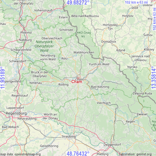
Cham GPS coordinates[2]
49° 13' 32.34" North, 12° 39' 18.036" East
| Map corner | latitude | longitude |
|---|---|---|
| Upper-left | 49.68272°, | 11.95189° |
| Center: | 49.22565°, | 12.65501° |
| Lower-right: | 48.76432°, | 13.35814° |
| Map W x H: | 102.1×102.1 km | = 63.4×63.4mi |
| max Lat: | 55.01917° ⇑80% North |
| Cham: | 49.22565° |
| min Lat: | ⇓20% South 47.40724° |
| min Long | Cham | max Long |
| 5.92978° | 12.65501° | 14.98853° |
| W 89.4%⇐ | ⇒10.6% E |
Elevation
Elevation of Cham is 396 m = 1299 ft, and this is 146.9 m = 482 ft above average elevation for this country.
| Max E: |
1256 m = 4121 ft | 25.2% |
| Cham | 396 m 1299 ft | |
| Avg. | 249.1 m = 817 ft | |
Min E: |
-5 m = -16 ft | 74.8% |
See also: Germany elevation on elevation.city.
Geographical zone
Cham is located in North temperate zone (between Tropic of Cancer and the Arctic Circle). Distance of this North polar circle is 1927.8 km =1197.9 mi to North.| Distance of | km | miles | from Cham |
|---|---|---|---|
| North Pole | 4533.7 | 2817.1 | to North |
| Arctic Circle | 1927.8 | 1197.9 | to North |
| Tropic Cancer | 2867.5 | 1781.8 | to South |
| Equator | 5473.4 | 3401 | to South |


Nearby cities:
15 places around Cham: (largest is in red/bold)
• Arnschwang
13 km =8.1 mi,  64°
64°
• Chamerau
7.5 km =4.7 mi,  112°
112°
• Gleißenberg
11.6 km =7.2 mi,  29°
29°
• Miltach
10.9 km =6.8 mi,  130°
130°
• Pemfling
5.3 km =3.3 mi,  328°
328°
• Pösing
7.7 km =4.8 mi,  276°
276°
• Roding
10.4 km =6.5 mi,  250°
250°
• Runding
7.9 km =4.9 mi,  98°
98°
• Schorndorf
8.5 km =5.3 mi,  211°
211°
• Stamsried
10.2 km =6.3 mi,  297°
297°
• Traitsching
8.4 km =5.2 mi,  182°
182°
• Waffenbrunn
4.6 km =2.9 mi,  10°
10°
• Weiding
8.9 km =5.5 mi, 62°
• Willmering
2.8 km =1.7 mi,  17°
17°
• Zandt
10.2 km =6.3 mi,  145°
145°
Sources, notices
• [Note1] Compared only with cities in Germany existing in our database
• [Src1] Map data: © OpenStreetMap contributors (CC-BY-SA)
• [Src2] Other city data from geonames.org with taken over terms of usage.
• [Src3] Geographical zone / Annual Mean Temperature by Robert A. Rohde @ Wikipedia
