Waldlaubersheim geodata
Waldlaubersheim (Rheinland-Pfalz) is a seat of a fourth-order administrative division; located in Germany in Europe/Berlin (GMT+2) time zone. With population of 804 people, there are 7882 cities with bigger population in this country. Compared to other cities in Germany, 65.6% of cities are located further ↑North; 80.4% of cities are located further →East and 55.7% of cities have lower elevation than Waldlaubersheim. Note1
Administrative division(s):
- Level 1: Rheinland-Pfalz
- Level 3: Landkreis Bad Kreuznach
- Level 4: Waldlaubersheim


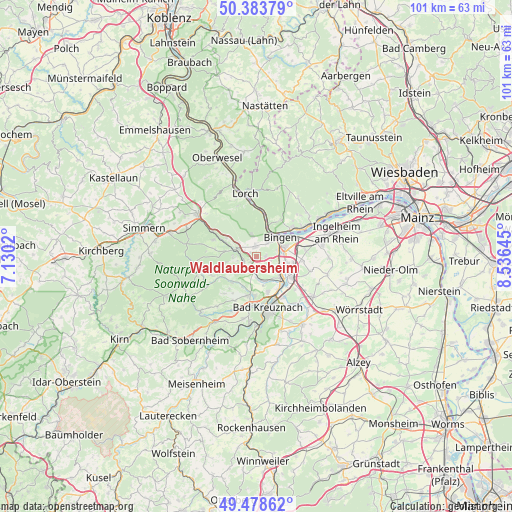
Waldlaubersheim GPS coordinates[2]
49° 55' 59.988" North, 7° 49' 59.988" East
| Map corner | latitude | longitude |
|---|---|---|
| Upper-left | 50.38379°, | 7.1302° |
| Center: | 49.93333°, | 7.83333° |
| Lower-right: | 49.47862°, | 8.53645° |
| Map W x H: | 100.6×100.6 km | = 62.5×62.5mi |
| max Lat: | 55.01917° ⇑65.6% North |
| Waldlaubersheim: | 49.93333° |
| min Lat: | ⇓34.4% South 47.40724° |
| min Long | Waldlaubersheim | max Long |
| 5.92978° | 7.83333° | 14.98853° |
| W 19.6%⇐ | ⇒80.4% E |
Elevation
Elevation of Waldlaubersheim is 263 m = 863 ft, and this is 13.9 m = 46 ft above average elevation for this country.
| Max E: |
1256 m = 4121 ft | 44.3% |
| Waldlaubersheim | 263 m 863 ft | |
| Avg. | 249.1 m = 817 ft | |
Min E: |
-5 m = -16 ft | 55.7% |
See also: Germany elevation on elevation.city.
Geographical zone
Waldlaubersheim is located in North temperate zone (between Tropic of Cancer and the Arctic Circle). Distance of this North polar circle is 1849.1 km =1149 mi to North.| Distance of | km | miles | from Waldlaubersheim |
|---|---|---|---|
| North Pole | 4455 | 2768.2 | to North |
| Arctic Circle | 1849.1 | 1149 | to North |
| Tropic Cancer | 2946.1 | 1830.6 | to South |
| Equator | 5552.1 | 3449.9 | to South |


Nearby cities:
15 places around Waldlaubersheim: (largest is in red/bold)
• Bingen am Rhein
6 km =3.7 mi,  51°
51°
• Dorsheim
3 km =1.9 mi,  107°
107°
• Eckenroth
4 km =2.5 mi,  242°
242°
• Hergenfeld
6 km =3.7 mi,  232°
232°
• Langenlonsheim
6 km =3.7 mi,  127°
127°
• Laubenheim
5.1 km =3.2 mi, 111°
• Münster-Sarmsheim
4.5 km =2.8 mi,  75°
75°
• Roth
2.4 km =1.5 mi,  270°
270°
• Rümmelsheim
1.9 km =1.2 mi,  90°
90°
• Schweppenhausen
2.5 km =1.6 mi,  252°
252°
• Stromberg
4.5 km =2.8 mi,  285°
285°
• Waldalgesheim
1.9 km =1.2 mi,  0°
0°
• Warmsroth
4 km =2.5 mi,  297°
297°
• Weiler
3.5 km =2.2 mi,  40°
40°
• Windesheim
3.9 km =2.4 mi,  197°
197°
Sources, notices
• [Note1] Compared only with cities in Germany existing in our database
• [Src1] Map data: © OpenStreetMap contributors (CC-BY-SA)
• [Src2] Other city data from geonames.org with taken over terms of usage.
• [Src3] Geographical zone / Annual Mean Temperature by Robert A. Rohde @ Wikipedia
