Waldalgesheim geodata
Waldalgesheim (Rheinland-Pfalz) is a seat of a fourth-order administrative division; located in Germany in Europe/Berlin (GMT+2) time zone. With population of 3,676 people, there are 3493 cities with bigger population in this country. Compared to other cities in Germany, 65.2% of cities are located further ↑North; 80.4% of cities are located further →East and 60.2% of cities have lower elevation than Waldalgesheim. Note1
Administrative division(s):
- Level 1: Rheinland-Pfalz
- Level 3: Landkreis Mainz-Bingen
- Level 4: Waldalgesheim


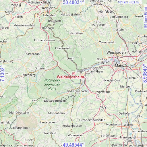
Waldalgesheim GPS coordinates[2]
49° 57' 0" North, 7° 49' 59.988" East
| Map corner | latitude | longitude |
|---|---|---|
| Upper-left | 50.40031°, | 7.1302° |
| Center: | 49.95°, | 7.83333° |
| Lower-right: | 49.49544°, | 8.53645° |
| Map W x H: | 100.6×100.6 km | = 62.5×62.5mi |
| max Lat: | 55.01917° ⇑65.2% North |
| Waldalgesheim: | 49.95° |
| min Lat: | ⇓34.8% South 47.40724° |
| min Long | Waldalgesheim | max Long |
| 5.92978° | 7.83333° | 14.98853° |
| W 19.6%⇐ | ⇒80.4% E |
Elevation
Elevation of Waldalgesheim is 291 m = 955 ft, and this is 41.9 m = 137 ft above average elevation for this country.
| Max E: |
1256 m = 4121 ft | 39.8% |
| Waldalgesheim | 291 m 955 ft | |
| Avg. | 249.1 m = 817 ft | |
Min E: |
-5 m = -16 ft | 60.2% |
See also: Germany elevation on elevation.city.
Geographical zone
Waldalgesheim is located in North temperate zone (between Tropic of Cancer and the Arctic Circle). Distance of this North polar circle is 1847.3 km =1147.9 mi to North.| Distance of | km | miles | from Waldalgesheim |
|---|---|---|---|
| North Pole | 4453.1 | 2767 | to North |
| Arctic Circle | 1847.3 | 1147.9 | to North |
| Tropic Cancer | 2948 | 1831.8 | to South |
| Equator | 5553.9 | 3451 | to South |


Nearby cities:
15 places around Waldalgesheim: (largest is in red/bold)
• Bingen am Rhein
5.1 km =3.2 mi,  68°
68°
• Daxweiler
6.2 km =3.9 mi,  287°
287°
• Dorsheim
4 km =2.5 mi,  133°
133°
• Eckenroth
5.2 km =3.2 mi,  223°
223°
• Laubenheim
6 km =3.7 mi, 127°
• Münster-Sarmsheim
4.4 km =2.7 mi,  99°
99°
• Roth
3 km =1.9 mi,  232°
232°
• Rümmelsheim
2.7 km =1.7 mi, 134°
• Schweppenhausen
3.5 km =2.2 mi, 222°
• Stromberg
4.4 km =2.7 mi,  261°
261°
• Trechtingshausen
6.8 km =4.2 mi,  8°
8°
• Waldlaubersheim
1.9 km =1.2 mi,  180°
180°
• Warmsroth
3.6 km =2.2 mi,  270°
270°
• Weiler
2.4 km =1.5 mi, 71°
• Windesheim
5.7 km =3.5 mi,  192°
192°
Sources, notices
• [Note1] Compared only with cities in Germany existing in our database
• [Src1] Map data: © OpenStreetMap contributors (CC-BY-SA)
• [Src2] Other city data from geonames.org with taken over terms of usage.
• [Src3] Geographical zone / Annual Mean Temperature by Robert A. Rohde @ Wikipedia
