Rümmelsheim geodata
Rümmelsheim (Rheinland-Pfalz) is a seat of a fourth-order administrative division; located in Germany in Europe/Berlin (GMT+2) time zone. With population of 1,435 people, there are 6007 cities with bigger population in this country. Compared to other cities in Germany, 65.6% of cities are located further ↑North; 79.8% of cities are located further →East and 55.4% of cities have higher elevation than Rümmelsheim. Note1
Administrative division(s):
- Level 1: Rheinland-Pfalz
- Level 3: Landkreis Bad Kreuznach
- Level 4: Rümmelsheim


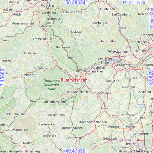
Rümmelsheim GPS coordinates[2]
49° 55' 59.052" North, 7° 51' 35.172" East
| Map corner | latitude | longitude |
|---|---|---|
| Upper-left | 50.38354°, | 7.15665° |
| Center: | 49.93307°, | 7.85977° |
| Lower-right: | 49.47835°, | 8.5629° |
| Map W x H: | 100.6×100.6 km | = 62.5×62.5mi |
| max Lat: | 55.01917° ⇑65.6% North |
| Rümmelsheim: | 49.93307° |
| min Lat: | ⇓34.4% South 47.40724° |
| min Long | Rümmelsheim | max Long |
| 5.92978° | 7.85977° | 14.98853° |
| W 20.2%⇐ | ⇒79.8% E |
Elevation
Elevation of Rümmelsheim is 186 m = 610 ft, and this is 63.1 m = 207 ft below average elevation for this country.
| Max E: |
1256 m = 4121 ft | 55.4% |
| Avg. | 249.1 m = 817 ft | |
| Rümmelsheim | 186 m = 610 ft | |
Min E: |
-5 m = -16 ft | 44.6% |
See also: Germany elevation on elevation.city.
Geographical zone
Rümmelsheim is located in North temperate zone (between Tropic of Cancer and the Arctic Circle). Distance of this North polar circle is 1849.1 km =1149 mi to North.| Distance of | km | miles | from Rümmelsheim |
|---|---|---|---|
| North Pole | 4455 | 2768.2 | to North |
| Arctic Circle | 1849.1 | 1149 | to North |
| Tropic Cancer | 2946.1 | 1830.6 | to South |
| Equator | 5552 | 3449.9 | to South |


Nearby cities:
15 places around Rümmelsheim: (largest is in red/bold)
• Bingen am Rhein
4.7 km =2.9 mi,  36°
36°
• Dorsheim
1.3 km =0.8 mi,  131°
131°
• Eckenroth
5.8 km =3.6 mi,  251°
251°
• Grolsheim
4.9 km =3 mi,  124°
124°
• Langenlonsheim
4.7 km =2.9 mi,  141°
141°
• Laubenheim
3.4 km =2.1 mi, 122°
• Münster-Sarmsheim
2.7 km =1.7 mi,  65°
65°
• Roth
4.3 km =2.7 mi,  270°
270°
• Schweppenhausen
4.4 km =2.7 mi,  260°
260°
• Stromberg
6.3 km =3.9 mi,  280°
280°
• Waldalgesheim
2.7 km =1.7 mi,  314°
314°
• Waldlaubersheim
1.9 km =1.2 mi, 270°
• Warmsroth
5.8 km =3.6 mi,  288°
288°
• Weiler
2.7 km =1.7 mi,  7°
7°
• Windesheim
4.8 km =3 mi,  220°
220°
Sources, notices
• [Note1] Compared only with cities in Germany existing in our database
• [Src1] Map data: © OpenStreetMap contributors (CC-BY-SA)
• [Src2] Other city data from geonames.org with taken over terms of usage.
• [Src3] Geographical zone / Annual Mean Temperature by Robert A. Rohde @ Wikipedia
