Weiler geodata
Weiler (Rheinland-Pfalz) is a populated place; located in Germany in Europe/Berlin (GMT+2) time zone. With population of 2,712 people, there are 4222 cities with bigger population in this country. Compared to other cities in Germany, 64.9% of cities are located further ↑North; 79.8% of cities are located further →East and 54.7% of cities have lower elevation than Weiler. Note1
Administrative division(s):
- Level 1: Rheinland-Pfalz
- Level 3: Landkreis Mainz-Bingen
- Level 4: Weiler bei Bingen


Weiler GPS coordinates[2]
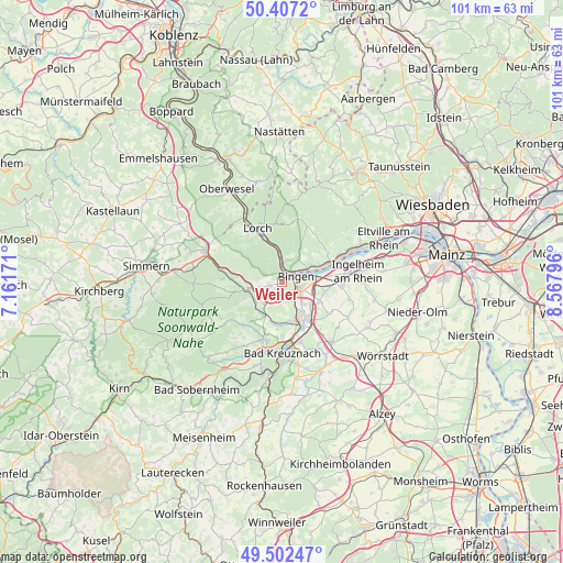
49° 57' 25.056" North, 7° 51' 53.424" East
| Map corner | latitude | longitude |
|---|---|---|
| Upper-left | 50.4072°, | 7.16171° |
| Center: | 49.95696°, | 7.86484° |
| Lower-right: | 49.50247°, | 8.56796° |
| Map W x H: | 100.6×100.6 km | = 62.5×62.5mi |
| max Lat: | 55.01917° ⇑64.9% North |
| Weiler: | 49.95696° |
| min Lat: | ⇓35.1% South 47.40724° |
| min Long | Weiler | max Long |
| 5.92978° | 7.86484° | 14.98853° |
| W 20.2%⇐ | ⇒79.8% E |
Elevation
Elevation of Weiler is 256 m = 840 ft, and this is 6.9 m = 23 ft above average elevation for this country.
| Max E: |
1256 m = 4121 ft | 45.3% |
| Weiler | 256 m 840 ft | |
| Avg. | 249.1 m = 817 ft | |
Min E: |
-5 m = -16 ft | 54.7% |
See also: Germany elevation on elevation.city.
Geographical zone
Weiler is located in North temperate zone (between Tropic of Cancer and the Arctic Circle). Distance of this North polar circle is 1846.5 km =1147.4 mi to North.| Distance of | km | miles | from Weiler |
|---|---|---|---|
| North Pole | 4452.4 | 2766.6 | to North |
| Arctic Circle | 1846.5 | 1147.4 | to North |
| Tropic Cancer | 2948.8 | 1832.3 | to South |
| Equator | 5554.7 | 3451.5 | to South |


Nearby cities:
15 places around Weiler: (largest is in red/bold)
• Bingen am Rhein
2.7 km =1.7 mi,  66°
66°
• Dorsheim
3.6 km =2.2 mi,  170°
170°
• Grolsheim
6.5 km =4 mi,  145°
145°
• Langenlonsheim
6.8 km =4.2 mi,  158°
158°
• Laubenheim
5.1 km =3.2 mi, 150°
• Münster-Sarmsheim
2.6 km =1.6 mi,  125°
125°
• Roth
5.3 km =3.3 mi,  240°
240°
• Rüdesheim am Rhein
4.9 km =3 mi,  60°
60°
• Rümmelsheim
2.7 km =1.7 mi,  187°
187°
• Schweppenhausen
5.8 km =3.6 mi,  234°
234°
• Stromberg
6.7 km =4.2 mi,  257°
257°
• Trechtingshausen
6.1 km =3.8 mi,  347°
347°
• Waldalgesheim
2.4 km =1.5 mi,  251°
251°
• Waldlaubersheim
3.5 km =2.2 mi,  220°
220°
• Warmsroth
5.9 km =3.7 mi, 262°
Sources, notices
• [Note1] Compared only with cities in Germany existing in our database
• [Src1] Map data: © OpenStreetMap contributors (CC-BY-SA)
• [Src2] Other city data from geonames.org with taken over terms of usage.
• [Src3] Geographical zone / Annual Mean Temperature by Robert A. Rohde @ Wikipedia
