Behrenhoff geodata
Behrenhoff (Mecklenburg-Vorpommern) is a populated place; located in Germany in Europe/Berlin (GMT+2) time zone. With population of 631 people, there are 8646 cities with bigger population in this country. Compared to other cities in Germany, 92.7% of cities are located further ↓South; 95% of cities are located further ←West and 82.3% of cities have higher elevation than Behrenhoff. Note1
Administrative division(s):
- Level 1: Mecklenburg-Vorpommern
- Level 3: Vorpommern-Greifswald
- Level 4: Behrenhoff


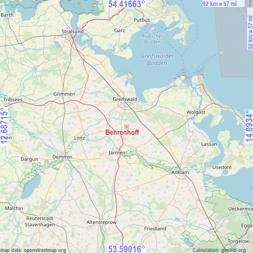
Behrenhoff GPS coordinates[2]
54° 0' 19.62" North, 13° 23' 24.972" East
| Map corner | latitude | longitude |
|---|---|---|
| Upper-left | 54.41663°, | 12.68715° |
| Center: | 54.00545°, | 13.39027° |
| Lower-right: | 53.59016°, | 14.0934° |
| Map W x H: | 91.9×91.9 km | = 57.1×57.1mi |
| max Lat: | 55.01917° ⇑7.3% North |
| Behrenhoff: | 54.00545° |
| min Lat: | ⇓92.7% South 47.40724° |
| min Long | Behrenhoff | max Long |
| 5.92978° | 13.39027° | 14.98853° |
| W 95%⇐ | ⇒5% E |
Elevation
Elevation of Behrenhoff is 41 m = 135 ft, and this is 208.1 m = 683 ft below average elevation for this country.
| Max E: |
1256 m = 4121 ft | 82.3% |
| Avg. | 249.1 m = 817 ft | |
| Behrenhoff | 41 m = 135 ft | |
Min E: |
-5 m = -16 ft | 17.7% |
See also: Germany elevation on elevation.city.
Geographical zone
Behrenhoff is located in North temperate zone (between Tropic of Cancer and the Arctic Circle). Distance of this North polar circle is 1396.3 km =867.6 mi to North.| Distance of | km | miles | from Behrenhoff |
|---|---|---|---|
| North Pole | 4002.2 | 2486.9 | to North |
| Arctic Circle | 1396.3 | 867.6 | to North |
| Tropic Cancer | 3398.9 | 2112 | to South |
| Equator | 6004.8 | 3731.2 | to South |


Nearby cities:
15 places around Behrenhoff: (largest is in red/bold)
• Bandelin
4.7 km =2.9 mi,  192°
192°
• Bentzin
10.1 km =6.3 mi,  229°
229°
• Dersekow
7.8 km =4.8 mi,  305°
305°
• Greifswald
9.7 km =6 mi,  359°
359°
• Groß Kiesow
5.8 km =3.6 mi,  82°
82°
• Görmin
8 km =5 mi,  258°
258°
• Hanshagen
10.9 km =6.8 mi,  66°
66°
• Hinrichshagen Hof
8 km =5 mi,  341°
341°
• Jarmen
9.6 km =6 mi,  199°
199°
• Kemnitz
12.4 km =7.7 mi,  49°
49°
• Neetzow
13.9 km =8.6 mi,  175°
175°
• Sassen
13.4 km =8.3 mi,  278°
278°
• Tutow
13.6 km =8.5 mi,  222°
222°
• Weitenhagen
5.5 km =3.4 mi,  13°
13°
• Züssow
10.8 km =6.7 mi,  106°
106°
Sources, notices
• [Note1] Compared only with cities in Germany existing in our database
• [Src1] Map data: © OpenStreetMap contributors (CC-BY-SA)
• [Src2] Other city data from geonames.org with taken over terms of usage.
• [Src3] Geographical zone / Annual Mean Temperature by Robert A. Rohde @ Wikipedia
