Ahlsdorf geodata
Ahlsdorf (Saxony-Anhalt) is a seat of a fourth-order administrative division; located in Germany in Europe/Berlin (GMT+2) time zone. With population of 1,912 people, there are 5186 cities with bigger population in this country. Compared to other cities in Germany, 66.8% of cities are located further ↓South; 73.8% of cities are located further ←West and 50.3% of cities have higher elevation than Ahlsdorf. Note1


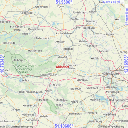
Ahlsdorf GPS coordinates[2]
51° 32' 43.548" North, 11° 27' 59.58" East
| Map corner | latitude | longitude |
|---|---|---|
| Upper-left | 51.9806°, | 10.76343° |
| Center: | 51.54543°, | 11.46655° |
| Lower-right: | 51.10606°, | 12.16968° |
| Map W x H: | 97.2×97.2 km | = 60.4×60.4mi |
| max Lat: | 55.01917° ⇑33.2% North |
| Ahlsdorf: | 51.54543° |
| min Lat: | ⇓66.8% South 47.40724° |
| min Long | Ahlsdorf | max Long |
| 5.92978° | 11.46655° | 14.98853° |
| W 73.8%⇐ | ⇒26.2% E |
Elevation
Elevation of Ahlsdorf is 223 m = 732 ft, and this is 26.1 m = 86 ft below average elevation for this country.
| Max E: |
1256 m = 4121 ft | 50.3% |
| Avg. | 249.1 m = 817 ft | |
| Ahlsdorf | 223 m = 732 ft | |
Min E: |
-5 m = -16 ft | 49.7% |
See also: Germany elevation on elevation.city.
Geographical zone
Ahlsdorf is located in North temperate zone (between Tropic of Cancer and the Arctic Circle). Distance of this North polar circle is 1669.9 km =1037.6 mi to North.| Distance of | km | miles | from Ahlsdorf |
|---|---|---|---|
| North Pole | 4275.7 | 2656.8 | to North |
| Arctic Circle | 1669.9 | 1037.6 | to North |
| Tropic Cancer | 3125.4 | 1942 | to South |
| Equator | 5731.3 | 3561.3 | to South |


Nearby cities:
15 places around Ahlsdorf: (largest is in red/bold)
• Annarode
4.4 km =2.7 mi,  276°
276°
• Benndorf
3.3 km =2.1 mi,  33°
33°
• Blankenheim
5 km =3.1 mi,  211°
211°
• Bornstedt
7 km =4.3 mi,  170°
170°
• Eisleben Lutherstadt
6 km =3.7 mi,  109°
109°
• Emseloh
7.1 km =4.4 mi,  226°
226°
• Helbra
2.4 km =1.5 mi,  77°
77°
• Hergisdorf
1.8 km =1.1 mi,  139°
139°
• Klostermansfeld
4.8 km =3 mi, 28°
• Mansfeld
5.3 km =3.3 mi,  349°
349°
• Siebigerode
3.4 km =2.1 mi,  308°
308°
• Vatterode
6.4 km =4 mi,  338°
338°
• Volkstedt
6.5 km =4 mi,  72°
72°
• Wimmelburg
3.9 km =2.4 mi,  134°
134°
• Wolferode
5.4 km =3.4 mi, 143°
Sources, notices
• [Note1] Compared only with cities in Germany existing in our database
• [Src1] Map data: © OpenStreetMap contributors (CC-BY-SA)
• [Src2] Other city data from geonames.org with taken over terms of usage.
• [Src3] Geographical zone / Annual Mean Temperature by Robert A. Rohde @ Wikipedia
