Visselhövede geodata
Visselhövede (Lower Saxony) is a populated place; located in Germany in Europe/Berlin (GMT+2) time zone. With population of 10,808 people, there are 1529 cities with bigger population in this country. Compared to other cities in Germany, 81.7% of cities are located further ↓South; 56.5% of cities are located further →East and 75.8% of cities have higher elevation than Visselhövede. Note1


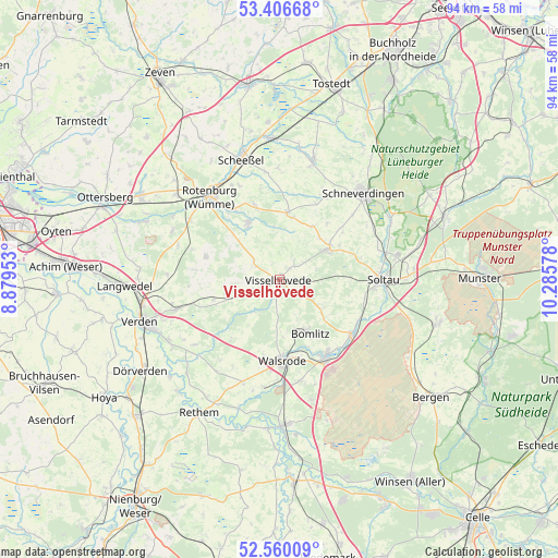
Visselhövede GPS coordinates[2]
52° 59' 7.656" North, 9° 34' 57.54" East
| Map corner | latitude | longitude |
|---|---|---|
| Upper-left | 53.40668°, | 8.87953° |
| Center: | 52.98546°, | 9.58265° |
| Lower-right: | 52.56009°, | 10.28578° |
| Map W x H: | 94.1×94.1 km | = 58.5×58.5mi |
| max Lat: | 55.01917° ⇑18.3% North |
| Visselhövede: | 52.98546° |
| min Lat: | ⇓81.7% South 47.40724° |
| min Long | Visselhövede | max Long |
| 5.92978° | 9.58265° | 14.98853° |
| W 43.5%⇐ | ⇒56.5% E |
Elevation
Elevation of Visselhövede is 60 m = 197 ft, and this is 189.1 m = 620 ft below average elevation for this country.
| Max E: |
1256 m = 4121 ft | 75.8% |
| Avg. | 249.1 m = 817 ft | |
| Visselhövede | 60 m = 197 ft | |
Min E: |
-5 m = -16 ft | 24.2% |
See also: Germany elevation on elevation.city.
Geographical zone
Visselhövede is located in North temperate zone (between Tropic of Cancer and the Arctic Circle). Distance of this North polar circle is 1509.7 km =938.1 mi to North.| Distance of | km | miles | from Visselhövede |
|---|---|---|---|
| North Pole | 4115.6 | 2557.3 | to North |
| Arctic Circle | 1509.7 | 938.1 | to North |
| Tropic Cancer | 3285.5 | 2041.5 | to South |
| Equator | 5891.4 | 3660.7 | to South |


Nearby cities:
15 places around Visselhövede: (largest is in red/bold)
• Bad Fallingbostel
15.2 km =9.4 mi,  150°
150°
• Bomlitz
10.5 km =6.5 mi, 154°
• Bothel
10.6 km =6.6 mi,  328°
328°
• Brockel
13.5 km =8.4 mi,  340°
340°
• Buchholz
2.9 km =1.8 mi, 333°
• Hemsbünde
13.8 km =8.6 mi, 327°
• Hemslingen
10.9 km =6.8 mi,  6°
6°
• Kirchlinteln
18.4 km =11.4 mi,  254°
254°
• Kirchwalsede
12.7 km =7.9 mi,  285°
285°
• Neuenkirchen
9.8 km =6.1 mi,  57°
57°
• Rotenburg
18.1 km =11.2 mi,  320°
320°
• Soltau
17.5 km =10.9 mi,  89°
89°
• Walsrode
13.8 km =8.6 mi,  177°
177°
• Westerwalsede
15.4 km =9.6 mi, 290°
• Wittorf
5.3 km =3.3 mi,  303°
303°
Sources, notices
• [Note1] Compared only with cities in Germany existing in our database
• [Src1] Map data: © OpenStreetMap contributors (CC-BY-SA)
• [Src2] Other city data from geonames.org with taken over terms of usage.
• [Src3] Geographical zone / Annual Mean Temperature by Robert A. Rohde @ Wikipedia
