Kirchwalsede geodata
Kirchwalsede (Lower Saxony) is a seat of a fourth-order administrative division; located in Germany in Europe/Berlin (GMT+2) time zone. With population of 1,334 people, there are 6211 cities with bigger population in this country. Compared to other cities in Germany, 81.8% of cities are located further ↓South; 59.3% of cities are located further →East and 76.7% of cities have higher elevation than Kirchwalsede. Note1


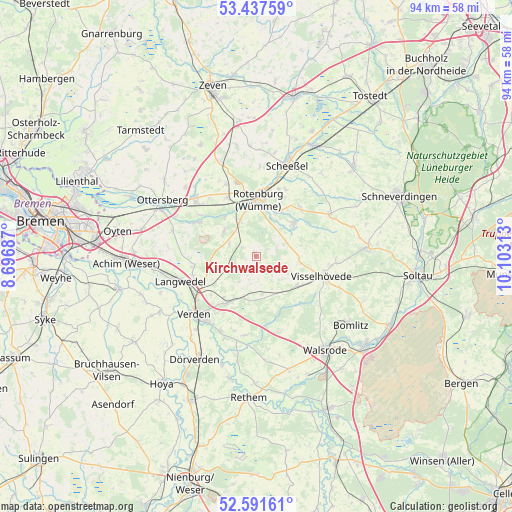
Kirchwalsede GPS coordinates[2]
53° 1' 0.012" North, 9° 24' 0" East
| Map corner | latitude | longitude |
|---|---|---|
| Upper-left | 53.43759°, | 8.69687° |
| Center: | 53.01667°, | 9.4° |
| Lower-right: | 52.59161°, | 10.10313° |
| Map W x H: | 94.1×94.1 km | = 58.5×58.5mi |
| max Lat: | 55.01917° ⇑18.2% North |
| Kirchwalsede: | 53.01667° |
| min Lat: | ⇓81.8% South 47.40724° |
| min Long | Kirchwalsede | max Long |
| 5.92978° | 9.4° | 14.98853° |
| W 40.7%⇐ | ⇒59.3% E |
Elevation
Elevation of Kirchwalsede is 57 m = 187 ft, and this is 192.1 m = 630 ft below average elevation for this country.
| Max E: |
1256 m = 4121 ft | 76.7% |
| Avg. | 249.1 m = 817 ft | |
| Kirchwalsede | 57 m = 187 ft | |
Min E: |
-5 m = -16 ft | 23.3% |
See also: Germany elevation on elevation.city.
Geographical zone
Kirchwalsede is located in North temperate zone (between Tropic of Cancer and the Arctic Circle). Distance of this North polar circle is 1506.3 km =936 mi to North.| Distance of | km | miles | from Kirchwalsede |
|---|---|---|---|
| North Pole | 4112.2 | 2555.2 | to North |
| Arctic Circle | 1506.3 | 936 | to North |
| Tropic Cancer | 3289 | 2043.7 | to South |
| Equator | 5894.9 | 3662.9 | to South |


Nearby cities:
15 places around Kirchwalsede: (largest is in red/bold)
• Ahausen
7.9 km =4.9 mi,  314°
314°
• Bothel
8.7 km =5.4 mi,  50°
50°
• Brockel
12.1 km =7.5 mi,  40°
40°
• Buchholz
10.9 km =6.8 mi,  94°
94°
• Bötersen
14.1 km =8.8 mi,  336°
336°
• Hassendorf
13.6 km =8.5 mi,  318°
318°
• Hellwege
12.7 km =7.9 mi,  299°
299°
• Hemsbünde
9.5 km =5.9 mi,  30°
30°
• Kirchlinteln
9.9 km =6.2 mi,  213°
213°
• Langwedel
15 km =9.3 mi,  253°
253°
• Rotenburg
10.5 km =6.5 mi,  3°
3°
• Scharnhorst
10.9 km =6.8 mi,  229°
229°
• Visselhövede
12.7 km =7.9 mi,  105°
105°
• Westerwalsede
2.9 km =1.8 mi, 309°
• Wittorf
7.8 km =4.8 mi, 93°
Sources, notices
• [Note1] Compared only with cities in Germany existing in our database
• [Src1] Map data: © OpenStreetMap contributors (CC-BY-SA)
• [Src2] Other city data from geonames.org with taken over terms of usage.
• [Src3] Geographical zone / Annual Mean Temperature by Robert A. Rohde @ Wikipedia
