Bad Fallingbostel geodata
Bad Fallingbostel (Lower Saxony) is a seat of a third-order administrative division; located in Germany in Europe/Berlin (GMT+2) time zone. With population of 13,473 people, there are 1191 cities with bigger population in this country. Compared to other cities in Germany, 80.8% of cities are located further ↓South; 54.4% of cities are located further →East and 83.2% of cities have higher elevation than Bad Fallingbostel. Note1
Administrative division(s):
- Level 1: Lower Saxony
- Level 3: Landkreis Heidekreis
- Level 4: Bad Fallingbostel


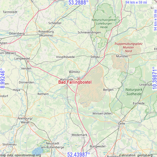
Bad Fallingbostel GPS coordinates[2]
52° 51' 59.076" North, 9° 41' 44.088" East
| Map corner | latitude | longitude |
|---|---|---|
| Upper-left | 53.2888°, | 8.99246° |
| Center: | 52.86641°, | 9.69558° |
| Lower-right: | 52.43987°, | 10.39871° |
| Map W x H: | 94.4×94.4 km | = 58.7×58.7mi |
| max Lat: | 55.01917° ⇑19.2% North |
| Bad Fallingbostel: | 52.86641° |
| min Lat: | ⇓80.8% South 47.40724° |
| min Long | Bad Fallingbost | max Long |
| 5.92978° | 9.69558° | 14.98853° |
| W 45.6%⇐ | ⇒54.4% E |
Elevation
Elevation of Bad Fallingbostel is 39 m = 128 ft, and this is 210.1 m = 689 ft below average elevation for this country.
| Max E: |
1256 m = 4121 ft | 83.2% |
| Avg. | 249.1 m = 817 ft | |
| Bad Fallingbostel | 39 m = 128 ft | |
Min E: |
-5 m = -16 ft | 16.8% |
See also: Germany elevation on elevation.city.
Geographical zone
Bad Fallingbostel is located in North temperate zone (between Tropic of Cancer and the Arctic Circle). Distance of this North polar circle is 1523 km =946.3 mi to North.| Distance of | km | miles | from Bad Fallingbostel |
|---|---|---|---|
| North Pole | 4128.9 | 2565.6 | to North |
| Arctic Circle | 1523 | 946.3 | to North |
| Tropic Cancer | 3272.3 | 2033.3 | to South |
| Equator | 5878.2 | 3652.5 | to South |


Nearby cities:
15 places around Bad Fallingbostel: (largest is in red/bold)
• Ahlden
15.3 km =9.5 mi,  219°
219°
• Bergen
19.1 km =11.9 mi,  109°
109°
• Bomlitz
4.8 km =3 mi,  320°
320°
• Buchholz
18.2 km =11.3 mi,  330°
330°
• Böhme
17.9 km =11.1 mi,  239°
239°
• Eickeloh
16.4 km =10.2 mi,  201°
201°
• Essel
19.8 km =12.3 mi,  190°
190°
• Gilten
20 km =12.4 mi, 202°
• Grethem
17.6 km =10.9 mi,  208°
208°
• Hademstorf
17.5 km =10.9 mi, 194°
• Hodenhagen
13.1 km =8.1 mi, 210°
• Neuenkirchen
18.5 km =11.5 mi,  2°
2°
• Soltau
16.6 km =10.3 mi,  36°
36°
• Visselhövede
15.2 km =9.4 mi, 330°
• Walsrode
6.9 km =4.3 mi,  265°
265°
Sources, notices
• [Note1] Compared only with cities in Germany existing in our database
• [Src1] Map data: © OpenStreetMap contributors (CC-BY-SA)
• [Src2] Other city data from geonames.org with taken over terms of usage.
• [Src3] Geographical zone / Annual Mean Temperature by Robert A. Rohde @ Wikipedia
