Rotenburg geodata
Rotenburg (Lower Saxony) is a seat of a third-order administrative division; located in Germany in Europe/Berlin (GMT+2) time zone. With population of 22,139 people, there are 680 cities with bigger population in this country. Compared to other cities in Germany, 82.4% of cities are located further ↓South; 59.2% of cities are located further →East and 90.5% of cities have higher elevation than Rotenburg. Note1
Administrative division(s):
- Level 1: Lower Saxony
- Level 3: Rotenburg (Wümme)
- Level 4: Rotenburg (Wümme)


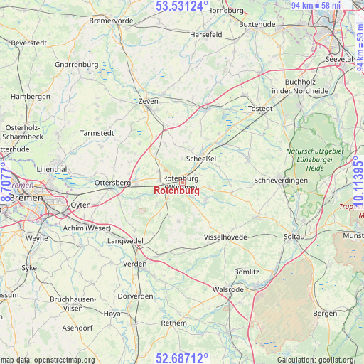
Rotenburg GPS coordinates[2]
53° 6' 40.5" North, 9° 24' 38.952" East
| Map corner | latitude | longitude |
|---|---|---|
| Upper-left | 53.53124°, | 8.7077° |
| Center: | 53.11125°, | 9.41082° |
| Lower-right: | 52.68712°, | 10.11395° |
| Map W x H: | 93.9×93.9 km | = 58.3×58.3mi |
| max Lat: | 55.01917° ⇑17.6% North |
| Rotenburg: | 53.11125° |
| min Lat: | ⇓82.4% South 47.40724° |
| min Long | Rotenburg | max Long |
| 5.92978° | 9.41082° | 14.98853° |
| W 40.8%⇐ | ⇒59.2% E |
Elevation
Elevation of Rotenburg is 20 m = 66 ft, and this is 229.1 m = 752 ft below average elevation for this country.
| Max E: |
1256 m = 4121 ft | 90.5% |
| Avg. | 249.1 m = 817 ft | |
| Rotenburg | 20 m = 66 ft | |
Min E: |
-5 m = -16 ft | 9.5% |
See also: Germany elevation on elevation.city.
Geographical zone
Rotenburg is located in North temperate zone (between Tropic of Cancer and the Arctic Circle). Distance of this North polar circle is 1495.8 km =929.4 mi to North.| Distance of | km | miles | from Rotenburg |
|---|---|---|---|
| North Pole | 4101.6 | 2548.6 | to North |
| Arctic Circle | 1495.8 | 929.4 | to North |
| Tropic Cancer | 3299.5 | 2050.2 | to South |
| Equator | 5905.4 | 3669.4 | to South |


Nearby cities:
15 places around Rotenburg: (largest is in red/bold)
• Ahausen
8 km =5 mi,  231°
231°
• Bothel
7.7 km =4.8 mi,  129°
129°
• Brockel
7.2 km =4.5 mi,  100°
100°
• Bötersen
6.7 km =4.2 mi,  291°
291°
• Hassendorf
9.7 km =6 mi,  268°
268°
• Hellwege
12.4 km =7.7 mi,  250°
250°
• Helvesiek
12.8 km =8 mi,  24°
24°
• Hemsbünde
4.8 km =3 mi,  119°
119°
• Hemslingen
13 km =8.1 mi, 103°
• Kirchwalsede
10.5 km =6.5 mi,  183°
183°
• Reeßum
13.2 km =8.2 mi,  280°
280°
• Scheeßel
7.8 km =4.8 mi,  38°
38°
• Sottrum
11.9 km =7.4 mi, 272°
• Westerwalsede
9.2 km =5.7 mi,  198°
198°
• Wittorf
13.1 km =8.1 mi,  147°
147°
Sources, notices
• [Note1] Compared only with cities in Germany existing in our database
• [Src1] Map data: © OpenStreetMap contributors (CC-BY-SA)
• [Src2] Other city data from geonames.org with taken over terms of usage.
• [Src3] Geographical zone / Annual Mean Temperature by Robert A. Rohde @ Wikipedia
