Brockel geodata
Brockel (Lower Saxony) is a seat of a fourth-order administrative division; located in Germany in Europe/Berlin (GMT+2) time zone. With population of 1,394 people, there are 6090 cities with bigger population in this country. Compared to other cities in Germany, 82.3% of cities are located further ↓South; 57.6% of cities are located further →East and 85.4% of cities have higher elevation than Brockel. Note1


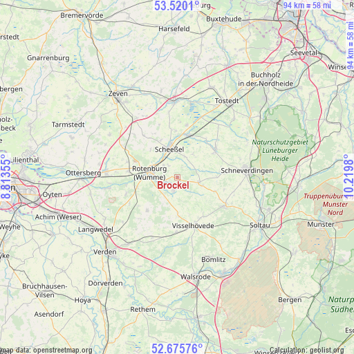
Brockel GPS coordinates[2]
53° 6' 0" North, 9° 31' 0.012" East
| Map corner | latitude | longitude |
|---|---|---|
| Upper-left | 53.5201°, | 8.81355° |
| Center: | 53.1°, | 9.51667° |
| Lower-right: | 52.67576°, | 10.2198° |
| Map W x H: | 93.9×93.9 km | = 58.3×58.3mi |
| max Lat: | 55.01917° ⇑17.7% North |
| Brockel: | 53.1° |
| min Lat: | ⇓82.3% South 47.40724° |
| min Long | Brockel | max Long |
| 5.92978° | 9.51667° | 14.98853° |
| W 42.4%⇐ | ⇒57.6% E |
Elevation
Elevation of Brockel is 34 m = 112 ft, and this is 215.1 m = 706 ft below average elevation for this country.
| Max E: |
1256 m = 4121 ft | 85.4% |
| Avg. | 249.1 m = 817 ft | |
| Brockel | 34 m = 112 ft | |
Min E: |
-5 m = -16 ft | 14.6% |
See also: Germany elevation on elevation.city.
Geographical zone
Brockel is located in North temperate zone (between Tropic of Cancer and the Arctic Circle). Distance of this North polar circle is 1497 km =930.2 mi to North.| Distance of | km | miles | from Brockel |
|---|---|---|---|
| North Pole | 4102.9 | 2549.4 | to North |
| Arctic Circle | 1497 | 930.2 | to North |
| Tropic Cancer | 3298.2 | 2049.4 | to South |
| Equator | 5904.2 | 3668.7 | to South |


Nearby cities:
15 places around Brockel: (largest is in red/bold)
• Ahausen
13.9 km =8.6 mi,  254°
254°
• Bothel
3.9 km =2.4 mi,  196°
196°
• Buchholz
10.6 km =6.6 mi,  163°
163°
• Fintel
13 km =8.1 mi,  51°
51°
• Helvesiek
13 km =8.1 mi,  352°
352°
• Hemsbünde
3.1 km =1.9 mi, 249°
• Hemslingen
5.9 km =3.7 mi,  108°
108°
• Kirchwalsede
12.1 km =7.5 mi,  220°
220°
• Lauenbrück
11.6 km =7.2 mi,  16°
16°
• Rotenburg
7.2 km =4.5 mi,  280°
280°
• Scheeßel
7.7 km =4.8 mi,  343°
343°
• Vahlde
12.2 km =7.6 mi,  39°
39°
• Visselhövede
13.5 km =8.4 mi, 160°
• Westerwalsede
12.5 km =7.8 mi,  233°
233°
• Wittorf
9.8 km =6.1 mi,  179°
179°
Sources, notices
• [Note1] Compared only with cities in Germany existing in our database
• [Src1] Map data: © OpenStreetMap contributors (CC-BY-SA)
• [Src2] Other city data from geonames.org with taken over terms of usage.
• [Src3] Geographical zone / Annual Mean Temperature by Robert A. Rohde @ Wikipedia
