Utendorf geodata
Utendorf (Thuringia) is a seat of a fourth-order administrative division; located in Germany in Europe/Berlin (GMT+2) time zone. With population of 509 people, there are 9330 cities with bigger population in this country. Compared to other cities in Germany, 50.2% of cities are located further ↑North; 57.7% of cities are located further ←West and 81.3% of cities have lower elevation than Utendorf. Note1
Administrative division(s):
- Level 1: Thuringia
- Level 3: Landkreis Schmalkalden-Meiningen
- Level 4: Utendorf


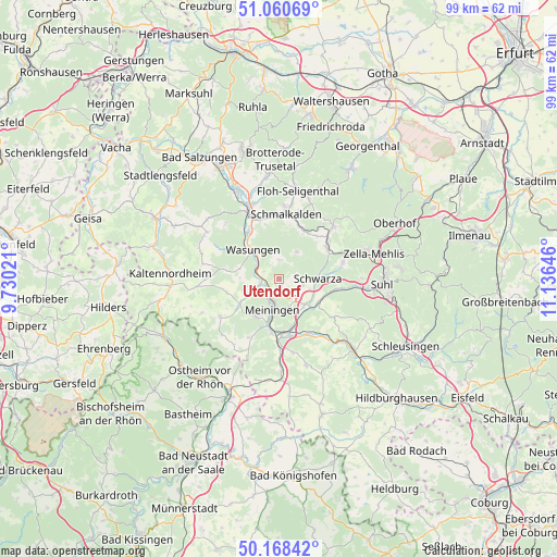
Utendorf GPS coordinates[2]
50° 37' 0.012" North, 10° 25' 59.988" East
| Map corner | latitude | longitude |
|---|---|---|
| Upper-left | 51.06069°, | 9.73021° |
| Center: | 50.61667°, | 10.43333° |
| Lower-right: | 50.16842°, | 11.13646° |
| Map W x H: | 99.2×99.2 km | = 61.6×61.6mi |
| max Lat: | 55.01917° ⇑50.2% North |
| Utendorf: | 50.61667° |
| min Lat: | ⇓49.8% South 47.40724° |
| min Long | Utendorf | max Long |
| 5.92978° | 10.43333° | 14.98853° |
| W 57.7%⇐ | ⇒42.3% E |
Elevation
Elevation of Utendorf is 442 m = 1450 ft, and this is 192.9 m = 633 ft above average elevation for this country.
| Max E: |
1256 m = 4121 ft | 18.7% |
| Utendorf | 442 m 1450 ft | |
| Avg. | 249.1 m = 817 ft | |
Min E: |
-5 m = -16 ft | 81.3% |
See also: Germany elevation on elevation.city.
Geographical zone
Utendorf is located in North temperate zone (between Tropic of Cancer and the Arctic Circle). Distance of this North polar circle is 1773.1 km =1101.8 mi to North.| Distance of | km | miles | from Utendorf |
|---|---|---|---|
| North Pole | 4379 | 2721 | to North |
| Arctic Circle | 1773.1 | 1101.8 | to North |
| Tropic Cancer | 3022.1 | 1877.8 | to South |
| Equator | 5628 | 3497.1 | to South |


Nearby cities:
15 places around Utendorf: (largest is in red/bold)
• Breitenbach
9 km =5.6 mi,  27°
27°
• Christes
6.6 km =4.1 mi, 32°
• Dillstädt
8 km =5 mi,  117°
117°
• Ellingshausen
7.8 km =4.8 mi,  162°
162°
• Herpf
8.3 km =5.2 mi,  238°
238°
• Kühndorf
4.1 km =2.5 mi,  102°
102°
• Mehmels
7.3 km =4.5 mi,  284°
284°
• Meiningen
5.6 km =3.5 mi,  193°
193°
• Metzels
3.4 km =2.1 mi,  1°
1°
• Rippershausen
6.2 km =3.9 mi,  252°
252°
• Rohr
6.4 km =4 mi,  134°
134°
• Schwarza
6.8 km =4.2 mi,  87°
87°
• Wallbach
3 km =1.9 mi,  308°
308°
• Walldorf
3.5 km =2.2 mi,  270°
270°
• Wasungen
6.8 km =4.2 mi,  318°
318°
Sources, notices
• [Note1] Compared only with cities in Germany existing in our database
• [Src1] Map data: © OpenStreetMap contributors (CC-BY-SA)
• [Src2] Other city data from geonames.org with taken over terms of usage.
• [Src3] Geographical zone / Annual Mean Temperature by Robert A. Rohde @ Wikipedia
