Herpf geodata
Herpf (Thuringia) is a populated place; located in Germany in Europe/Berlin (GMT+2) time zone. With population of 957 people, there are 7318 cities with bigger population in this country. Compared to other cities in Germany, 51.1% of cities are located further ↑North; 56% of cities are located further ←West and 65.1% of cities have lower elevation than Herpf. Note1
Administrative division(s):
- Level 1: Thuringia
- Level 3: Landkreis Schmalkalden-Meiningen
- Level 4: Meiningen


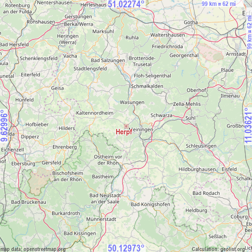
Herpf GPS coordinates[2]
50° 34' 42.06" North, 10° 19' 59.088" East
| Map corner | latitude | longitude |
|---|---|---|
| Upper-left | 51.02274°, | 9.62996° |
| Center: | 50.57835°, | 10.33308° |
| Lower-right: | 50.12973°, | 11.03621° |
| Map W x H: | 99.3×99.3 km | = 61.7×61.7mi |
| max Lat: | 55.01917° ⇑51.1% North |
| Herpf: | 50.57835° |
| min Lat: | ⇓48.9% South 47.40724° |
| min Long | Herpf | max Long |
| 5.92978° | 10.33308° | 14.98853° |
| W 56%⇐ | ⇒44% E |
Elevation
Elevation of Herpf is 322 m = 1056 ft, and this is 72.9 m = 239 ft above average elevation for this country.
| Max E: |
1256 m = 4121 ft | 34.9% |
| Herpf | 322 m 1056 ft | |
| Avg. | 249.1 m = 817 ft | |
Min E: |
-5 m = -16 ft | 65.1% |
See also: Germany elevation on elevation.city.
Geographical zone
Herpf is located in North temperate zone (between Tropic of Cancer and the Arctic Circle). Distance of this North polar circle is 1777.4 km =1104.4 mi to North.| Distance of | km | miles | from Herpf |
|---|---|---|---|
| North Pole | 4383.3 | 2723.7 | to North |
| Arctic Circle | 1777.4 | 1104.4 | to North |
| Tropic Cancer | 3017.9 | 1875.2 | to South |
| Equator | 5623.8 | 3494.5 | to South |


Nearby cities:
15 places around Herpf: (largest is in red/bold)
• Mehmels
6.1 km =3.8 mi,  0°
0°
• Meiningen
5.9 km =3.7 mi,  101°
101°
• Oberkatz
7.4 km =4.6 mi,  288°
288°
• Obermaßfeld-Grimmenthal
9.3 km =5.8 mi,  126°
126°
• Oepfershausen
9.5 km =5.9 mi,  317°
317°
• Rippershausen
2.7 km =1.7 mi,  26°
26°
• Stepfershausen
3.4 km =2.1 mi, 315°
• Sülzfeld
6.4 km =4 mi,  162°
162°
• Unterkatz
7.1 km =4.4 mi,  310°
310°
• Untermaßfeld
7.7 km =4.8 mi, 130°
• Utendorf
8.3 km =5.2 mi,  58°
58°
• Wahns
6.5 km =4 mi,  339°
339°
• Wallbach
7.7 km =4.8 mi,  37°
37°
• Walldorf
5.5 km =3.4 mi, 39°
• Wasungen
9.6 km =6 mi,  15°
15°
Sources, notices
• [Note1] Compared only with cities in Germany existing in our database
• [Src1] Map data: © OpenStreetMap contributors (CC-BY-SA)
• [Src2] Other city data from geonames.org with taken over terms of usage.
• [Src3] Geographical zone / Annual Mean Temperature by Robert A. Rohde @ Wikipedia
