Meiningen geodata
Meiningen (Thuringia) is a seat of a third-order administrative division; located in Germany in Europe/Berlin (GMT+2) time zone. With population of 21,580 people, there are 702 cities with bigger population in this country. Compared to other cities in Germany, 51.3% of cities are located further ↑North; 57.3% of cities are located further ←West and 60.4% of cities have lower elevation than Meiningen. Note1
Administrative division(s):
- Level 1: Thuringia
- Level 3: Landkreis Schmalkalden-Meiningen
- Level 4: Meiningen


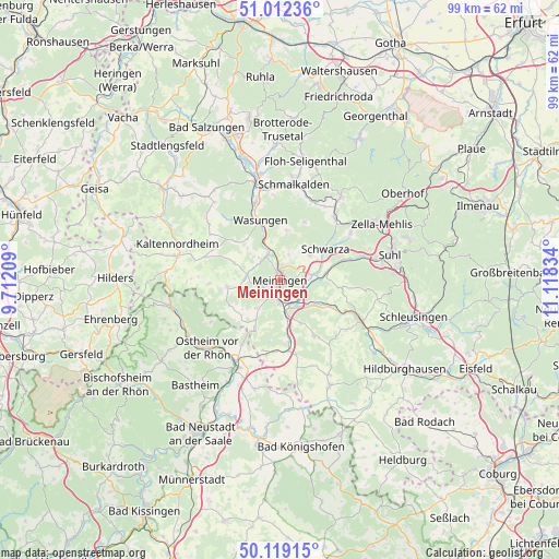
Meiningen GPS coordinates[2]
50° 34' 4.332" North, 10° 24' 54.756" East
| Map corner | latitude | longitude |
|---|---|---|
| Upper-left | 51.01236°, | 9.71209° |
| Center: | 50.56787°, | 10.41521° |
| Lower-right: | 50.11915°, | 11.11834° |
| Map W x H: | 99.3×99.3 km | = 61.7×61.7mi |
| max Lat: | 55.01917° ⇑51.3% North |
| Meiningen: | 50.56787° |
| min Lat: | ⇓48.7% South 47.40724° |
| min Long | Meiningen | max Long |
| 5.92978° | 10.41521° | 14.98853° |
| W 57.3%⇐ | ⇒42.7% E |
Elevation
Elevation of Meiningen is 292 m = 958 ft, and this is 42.9 m = 141 ft above average elevation for this country.
| Max E: |
1256 m = 4121 ft | 39.6% |
| Meiningen | 292 m 958 ft | |
| Avg. | 249.1 m = 817 ft | |
Min E: |
-5 m = -16 ft | 60.4% |
See also: Germany elevation on elevation.city.
Geographical zone
Meiningen is located in North temperate zone (between Tropic of Cancer and the Arctic Circle). Distance of this North polar circle is 1778.6 km =1105.2 mi to North.| Distance of | km | miles | from Meiningen |
|---|---|---|---|
| North Pole | 4384.4 | 2724.3 | to North |
| Arctic Circle | 1778.6 | 1105.2 | to North |
| Tropic Cancer | 3016.7 | 1874.5 | to South |
| Equator | 5622.6 | 3493.7 | to South |


Nearby cities:
15 places around Meiningen: (largest is in red/bold)
• Belrieth
7.1 km =4.4 mi,  127°
127°
• Einhausen
5.5 km =3.4 mi,  143°
143°
• Ellingshausen
4.1 km =2.5 mi,  118°
118°
• Herpf
5.9 km =3.7 mi,  281°
281°
• Kühndorf
6.9 km =4.3 mi,  49°
49°
• Neubrunn
8.4 km =5.2 mi,  154°
154°
• Obermaßfeld-Grimmenthal
4.7 km =2.9 mi,  158°
158°
• Rippershausen
5.8 km =3.6 mi,  307°
307°
• Ritschenhausen
6.5 km =4 mi,  169°
169°
• Rohr
5.9 km =3.7 mi,  80°
80°
• Sülzfeld
6.3 km =3.9 mi,  218°
218°
• Untermaßfeld
3.8 km =2.4 mi,  178°
178°
• Utendorf
5.6 km =3.5 mi,  13°
13°
• Wallbach
7.4 km =4.6 mi,  351°
351°
• Walldorf
5.9 km =3.7 mi,  337°
337°
Sources, notices
• [Note1] Compared only with cities in Germany existing in our database
• [Src1] Map data: © OpenStreetMap contributors (CC-BY-SA)
• [Src2] Other city data from geonames.org with taken over terms of usage.
• [Src3] Geographical zone / Annual Mean Temperature by Robert A. Rohde @ Wikipedia
