Noer geodata
Noer (Schleswig-Holstein) is a seat of a fourth-order administrative division; located in Germany in Europe/Berlin (GMT+2) time zone. With population of 902 people, there are 7516 cities with bigger population in this country. Compared to other cities in Germany, 97.8% of cities are located further ↓South; 50% of cities are located further ←West and 92.3% of cities have higher elevation than Noer. Note1
Administrative division(s):
- Level 1: Schleswig-Holstein
- Level 3: Kreis Rendsburg-Eckernförde
- Level 4: Noer


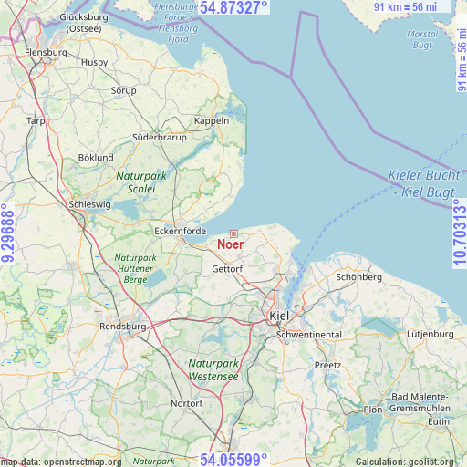
Noer GPS coordinates[2]
54° 28' 0.012" North, 10° 0' 0" East
| Map corner | latitude | longitude |
|---|---|---|
| Upper-left | 54.87327°, | 9.29688° |
| Center: | 54.46667°, | 10° |
| Lower-right: | 54.05599°, | 10.70313° |
| Map W x H: | 90.9×90.9 km | = 56.5×56.5mi |
| max Lat: | 55.01917° ⇑2.2% North |
| Noer: | 54.46667° |
| min Lat: | ⇓97.8% South 47.40724° |
| min Long | Noer | max Long |
| 5.92978° | 10° | 14.98853° |
| W 50%⇐ | ⇒50% E |
Elevation
Elevation of Noer is 15 m = 49 ft, and this is 234.1 m = 768 ft below average elevation for this country.
| Max E: |
1256 m = 4121 ft | 92.3% |
| Avg. | 249.1 m = 817 ft | |
| Noer | 15 m = 49 ft | |
Min E: |
-5 m = -16 ft | 7.7% |
See also: Germany elevation on elevation.city.
Geographical zone
Noer is located in North temperate zone (between Tropic of Cancer and the Arctic Circle). Distance of this North polar circle is 1345 km =835.7 mi to North.| Distance of | km | miles | from Noer |
|---|---|---|---|
| North Pole | 3950.9 | 2455 | to North |
| Arctic Circle | 1345 | 835.7 | to North |
| Tropic Cancer | 3450.2 | 2143.9 | to South |
| Equator | 6056.1 | 3763.1 | to South |


Nearby cities:
15 places around Noer: (largest is in red/bold)
• Altenhof
9.4 km =5.8 mi,  246°
246°
• Altenholz
11.4 km =7.1 mi,  130°
130°
• Barkelsby
11.4 km =7.1 mi,  288°
288°
• Dänischenhagen
9.2 km =5.7 mi,  117°
117°
• Eckernförde
10.5 km =6.5 mi,  271°
271°
• Felm
6.4 km =4 mi,  149°
149°
• Gettorf
7.5 km =4.7 mi,  188°
188°
• Lindau
11.3 km =7 mi,  214°
214°
• Loose
9.4 km =5.8 mi,  306°
306°
• Neudorf-Bornstein
4.9 km =3 mi,  221°
221°
• Neuwittenbek
11.2 km =7 mi,  174°
174°
• Osdorf
3.9 km =2.4 mi,  163°
163°
• Strande
11.4 km =7.1 mi,  108°
108°
• Tüttendorf
7.4 km =4.6 mi,  180°
180°
• Waabs
7.5 km =4.7 mi,  351°
351°
Sources, notices
• [Note1] Compared only with cities in Germany existing in our database
• [Src1] Map data: © OpenStreetMap contributors (CC-BY-SA)
• [Src2] Other city data from geonames.org with taken over terms of usage.
• [Src3] Geographical zone / Annual Mean Temperature by Robert A. Rohde @ Wikipedia
