Felm geodata
Felm (Schleswig-Holstein) is a seat of a fourth-order administrative division; located in Germany in Europe/Berlin (GMT+2) time zone. With population of 1,144 people, there are 6719 cities with bigger population in this country. Compared to other cities in Germany, 97.5% of cities are located further ↓South; 50.8% of cities are located further ←West and 91.2% of cities have higher elevation than Felm. Note1
Administrative division(s):
- Level 1: Schleswig-Holstein
- Level 3: Kreis Rendsburg-Eckernförde
- Level 4: Felm


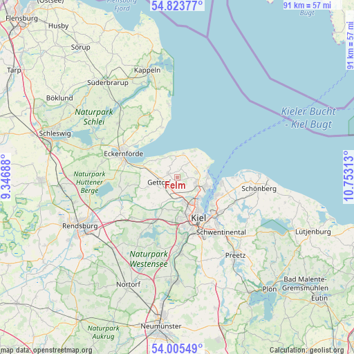
Felm GPS coordinates[2]
54° 25' 0.012" North, 10° 3' 0" East
| Map corner | latitude | longitude |
|---|---|---|
| Upper-left | 54.82377°, | 9.34688° |
| Center: | 54.41667°, | 10.05° |
| Lower-right: | 54.00549°, | 10.75313° |
| Map W x H: | 91×91 km | = 56.5×56.5mi |
| max Lat: | 55.01917° ⇑2.5% North |
| Felm: | 54.41667° |
| min Lat: | ⇓97.5% South 47.40724° |
| min Long | Felm | max Long |
| 5.92978° | 10.05° | 14.98853° |
| W 50.8%⇐ | ⇒49.2% E |
Elevation
Elevation of Felm is 18 m = 59 ft, and this is 231.1 m = 758 ft below average elevation for this country.
| Max E: |
1256 m = 4121 ft | 91.2% |
| Avg. | 249.1 m = 817 ft | |
| Felm | 18 m = 59 ft | |
Min E: |
-5 m = -16 ft | 8.8% |
See also: Germany elevation on elevation.city.
Geographical zone
Felm is located in North temperate zone (between Tropic of Cancer and the Arctic Circle). Distance of this North polar circle is 1350.6 km =839.2 mi to North.| Distance of | km | miles | from Felm |
|---|---|---|---|
| North Pole | 3956.5 | 2458.5 | to North |
| Arctic Circle | 1350.6 | 839.2 | to North |
| Tropic Cancer | 3444.6 | 2140.4 | to South |
| Equator | 6050.6 | 3759.7 | to South |


Nearby cities:
15 places around Felm: (largest is in red/bold)
• Altenholz
5.7 km =3.5 mi,  108°
108°
• Dänischenhagen
5.1 km =3.2 mi,  75°
75°
• Gettorf
4.7 km =2.9 mi,  246°
246°
• Heikendorf
11.2 km =7 mi,  119°
119°
• Kronshagen
9.5 km =5.9 mi,  166°
166°
• Laboe
10.9 km =6.8 mi,  99°
99°
• Lindau
10.4 km =6.5 mi, 249°
• Neudorf-Bornstein
6.7 km =4.2 mi,  285°
285°
• Neuwittenbek
6 km =3.7 mi,  201°
201°
• Noer
6.4 km =4 mi,  329°
329°
• Osdorf
2.8 km =1.7 mi,  310°
310°
• Ottendorf
8.4 km =5.2 mi,  180°
180°
• Quarnbek
10.2 km =6.3 mi, 204°
• Strande
7.8 km =4.8 mi, 76°
• Tüttendorf
3.7 km =2.3 mi,  240°
240°
Sources, notices
• [Note1] Compared only with cities in Germany existing in our database
• [Src1] Map data: © OpenStreetMap contributors (CC-BY-SA)
• [Src2] Other city data from geonames.org with taken over terms of usage.
• [Src3] Geographical zone / Annual Mean Temperature by Robert A. Rohde @ Wikipedia
