Tröstau geodata
Tröstau (Bavaria) is a seat of a fourth-order administrative division; located in Germany in Europe/Berlin (GMT+2) time zone. With population of 2,583 people, there are 4347 cities with bigger population in this country. Compared to other cities in Germany, 63.5% of cities are located further ↑North; 81.1% of cities are located further ←West and 92.6% of cities have lower elevation than Tröstau. Note1
Administrative division(s):
- Level 1: Bavaria
- Level 2: Upper Franconia
- Level 3: Landkreis Wunsiedel im Fichtelgebirge
- Level 4: Tröstau


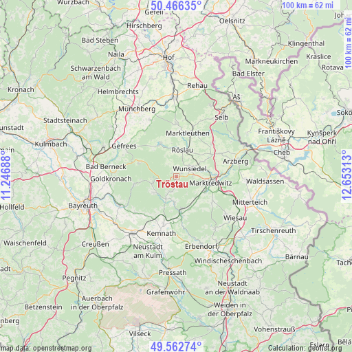
Tröstau GPS coordinates[2]
50° 1' 0.012" North, 11° 57' 0" East
| Map corner | latitude | longitude |
|---|---|---|
| Upper-left | 50.46635°, | 11.24688° |
| Center: | 50.01667°, | 11.95° |
| Lower-right: | 49.56274°, | 12.65313° |
| Map W x H: | 100.5×100.5 km | = 62.4×62.4mi |
| max Lat: | 55.01917° ⇑63.5% North |
| Tröstau: | 50.01667° |
| min Lat: | ⇓36.5% South 47.40724° |
| min Long | Tröstau | max Long |
| 5.92978° | 11.95° | 14.98853° |
| W 81.1%⇐ | ⇒18.9% E |
Elevation
Elevation of Tröstau is 552 m = 1811 ft, and this is 302.9 m = 994 ft above average elevation for this country.
| Max E: |
1256 m = 4121 ft | 7.4% |
| Tröstau | 552 m 1811 ft | |
| Avg. | 249.1 m = 817 ft | |
Min E: |
-5 m = -16 ft | 92.6% |
See also: Germany elevation on elevation.city.
Geographical zone
Tröstau is located in North temperate zone (between Tropic of Cancer and the Arctic Circle). Distance of this North polar circle is 1839.8 km =1143.2 mi to North.| Distance of | km | miles | from Tröstau |
|---|---|---|---|
| North Pole | 4445.7 | 2762.4 | to North |
| Arctic Circle | 1839.8 | 1143.2 | to North |
| Tropic Cancer | 2955.4 | 1836.4 | to South |
| Equator | 5561.3 | 3455.6 | to South |


Nearby cities:
15 places around Tröstau: (largest is in red/bold)
• Bad Alexandersbad
4.8 km =3 mi,  90°
90°
• Bischofsgrün
11.4 km =7.1 mi,  289°
289°
• Brand
6.9 km =4.3 mi,  203°
203°
• Ebnath
7.5 km =4.7 mi,  189°
189°
• Fichtelberg
7 km =4.3 mi,  257°
257°
• Grub
9.7 km =6 mi,  351°
351°
• Marktredwitz
9.8 km =6.1 mi,  97°
97°
• Mehlmeisel
7.9 km =4.9 mi,  233°
233°
• Nagel
4.4 km =2.7 mi,  212°
212°
• Neusorg
9.3 km =5.8 mi,  172°
172°
• Pullenreuth
9.9 km =6.2 mi,  158°
158°
• Röslau
7.8 km =4.8 mi,  17°
17°
• Waldershof
9 km =5.6 mi,  115°
115°
• Weißenstadt
10.5 km =6.5 mi,  335°
335°
• Wunsiedel
4.6 km =2.9 mi,  56°
56°
Sources, notices
• [Note1] Compared only with cities in Germany existing in our database
• [Src1] Map data: © OpenStreetMap contributors (CC-BY-SA)
• [Src2] Other city data from geonames.org with taken over terms of usage.
• [Src3] Geographical zone / Annual Mean Temperature by Robert A. Rohde @ Wikipedia
