Röslau geodata
Röslau (Bavaria) is a seat of a fourth-order administrative division; located in Germany in Europe/Berlin (GMT+2) time zone. With population of 2,402 people, there are 4559 cities with bigger population in this country. Compared to other cities in Germany, 61.8% of cities are located further ↑North; 81.6% of cities are located further ←West and 93.3% of cities have lower elevation than Röslau. Note1
Administrative division(s):
- Level 1: Bavaria
- Level 2: Upper Franconia
- Level 3: Landkreis Wunsiedel im Fichtelgebirge
- Level 4: Röslau


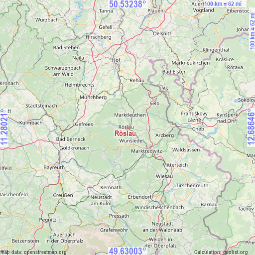
Röslau GPS coordinates[2]
50° 4' 59.988" North, 11° 58' 59.988" East
| Map corner | latitude | longitude |
|---|---|---|
| Upper-left | 50.53238°, | 11.28021° |
| Center: | 50.08333°, | 11.98333° |
| Lower-right: | 49.63003°, | 12.68646° |
| Map W x H: | 100.3×100.3 km | = 62.3×62.3mi |
| max Lat: | 55.01917° ⇑61.8% North |
| Röslau: | 50.08333° |
| min Lat: | ⇓38.2% South 47.40724° |
| min Long | Röslau | max Long |
| 5.92978° | 11.98333° | 14.98853° |
| W 81.6%⇐ | ⇒18.4% E |
Elevation
Elevation of Röslau is 563 m = 1847 ft, and this is 313.9 m = 1030 ft above average elevation for this country.
| Max E: |
1256 m = 4121 ft | 6.7% |
| Röslau | 563 m 1847 ft | |
| Avg. | 249.1 m = 817 ft | |
Min E: |
-5 m = -16 ft | 93.3% |
See also: Germany elevation on elevation.city.
Geographical zone
Röslau is located in North temperate zone (between Tropic of Cancer and the Arctic Circle). Distance of this North polar circle is 1832.4 km =1138.6 mi to North.| Distance of | km | miles | from Röslau |
|---|---|---|---|
| North Pole | 4438.3 | 2757.8 | to North |
| Arctic Circle | 1832.4 | 1138.6 | to North |
| Tropic Cancer | 2962.8 | 1841 | to South |
| Equator | 5568.7 | 3460.2 | to South |


Nearby cities:
15 places around Röslau: (largest is in red/bold)
• Bad Alexandersbad
7.8 km =4.8 mi,  162°
162°
• Fichtelberg
12.8 km =8 mi,  225°
225°
• Grub
4.4 km =2.7 mi,  299°
299°
• Höchstädt bei Thiersheim
7.7 km =4.8 mi,  74°
74°
• Kirchenlamitz
8 km =5 mi,  341°
341°
• Marktleuthen
5.4 km =3.4 mi,  14°
14°
• Marktredwitz
11.4 km =7.1 mi,  140°
140°
• Nagel
12.1 km =7.5 mi,  203°
203°
• Thiersheim
10.2 km =6.3 mi,  94°
94°
• Thierstein
8.8 km =5.5 mi, 73°
• Tröstau
7.8 km =4.8 mi, 197°
• Waldershof
12.7 km =7.9 mi,  153°
153°
• Weißenstadt
7.1 km =4.4 mi,  287°
287°
• Wunsiedel
5.1 km =3.2 mi, 163°
• Zell im Fichtelgebirge
12.8 km =8 mi, 296°
Sources, notices
• [Note1] Compared only with cities in Germany existing in our database
• [Src1] Map data: © OpenStreetMap contributors (CC-BY-SA)
• [Src2] Other city data from geonames.org with taken over terms of usage.
• [Src3] Geographical zone / Annual Mean Temperature by Robert A. Rohde @ Wikipedia
