Grub geodata
Grub (Bavaria) is a populated place; located in Germany in Europe/Berlin (GMT+2) time zone. With population of 3,129 people, there are 3889 cities with bigger population in this country. Compared to other cities in Germany, 61.1% of cities are located further ↑North; 80.7% of cities are located further ←West and 95.6% of cities have lower elevation than Grub. Note1
Administrative division(s):
- Level 1: Bavaria
- Level 2: Upper Franconia
- Level 3: Landkreis Wunsiedel im Fichtelgebirge
- Level 4: Weißenstadt


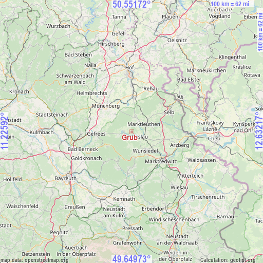
Grub GPS coordinates[2]
50° 6' 10.26" North, 11° 55' 44.544" East
| Map corner | latitude | longitude |
|---|---|---|
| Upper-left | 50.55172°, | 11.22592° |
| Center: | 50.10285°, | 11.92904° |
| Lower-right: | 49.64973°, | 12.63217° |
| Map W x H: | 100.3×100.3 km | = 62.3×62.3mi |
| max Lat: | 55.01917° ⇑61.1% North |
| Grub: | 50.10285° |
| min Lat: | ⇓38.9% South 47.40724° |
| min Long | Grub | max Long |
| 5.92978° | 11.92904° | 14.98853° |
| W 80.7%⇐ | ⇒19.3% E |
Elevation
Elevation of Grub is 614 m = 2014 ft, and this is 364.9 m = 1197 ft above average elevation for this country.
| Max E: |
1256 m = 4121 ft | 4.4% |
| Grub | 614 m 2014 ft | |
| Avg. | 249.1 m = 817 ft | |
Min E: |
-5 m = -16 ft | 95.6% |
See also: Germany elevation on elevation.city.
Geographical zone
Grub is located in North temperate zone (between Tropic of Cancer and the Arctic Circle). Distance of this North polar circle is 1830.3 km =1137.3 mi to North.| Distance of | km | miles | from Grub |
|---|---|---|---|
| North Pole | 4436.1 | 2756.5 | to North |
| Arctic Circle | 1830.3 | 1137.3 | to North |
| Tropic Cancer | 2965 | 1842.4 | to South |
| Equator | 5570.9 | 3461.6 | to South |


Nearby cities:
15 places around Grub: (largest is in red/bold)
• Bad Alexandersbad
11.4 km =7.1 mi,  146°
146°
• Bischofsgrün
10.9 km =6.8 mi,  238°
238°
• Fichtelberg
12.3 km =7.6 mi,  205°
205°
• Höchstädt bei Thiersheim
11.3 km =7 mi,  90°
90°
• Kirchenlamitz
5.6 km =3.5 mi,  14°
14°
• Marktleuthen
6 km =3.7 mi,  59°
59°
• Oberhaid
9.2 km =5.7 mi,  286°
286°
• Röslau
4.4 km =2.7 mi,  119°
119°
• Sparneck
9 km =5.6 mi,  317°
317°
• Thierstein
12.3 km =7.6 mi, 88°
• Tröstau
9.7 km =6 mi,  171°
171°
• Weißdorf
10.6 km =6.6 mi,  327°
327°
• Weißenstadt
2.9 km =1.8 mi,  268°
268°
• Wunsiedel
8.8 km =5.5 mi,  143°
143°
• Zell im Fichtelgebirge
8.4 km =5.2 mi,  295°
295°
Sources, notices
• [Note1] Compared only with cities in Germany existing in our database
• [Src1] Map data: © OpenStreetMap contributors (CC-BY-SA)
• [Src2] Other city data from geonames.org with taken over terms of usage.
• [Src3] Geographical zone / Annual Mean Temperature by Robert A. Rohde @ Wikipedia
