Mehlmeisel geodata
Mehlmeisel (Bavaria) is a seat of a fourth-order administrative division; located in Germany in Europe/Berlin (GMT+2) time zone. With population of 1,409 people, there are 6064 cities with bigger population in this country. Compared to other cities in Germany, 64.5% of cities are located further ↑North; 79.7% of cities are located further ←West and 96% of cities have lower elevation than Mehlmeisel. Note1
Administrative division(s):
- Level 1: Bavaria
- Level 2: Upper Franconia
- Level 3: Landkreis Bayreuth
- Level 4: Mehlmeisel


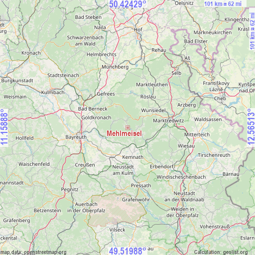
Mehlmeisel GPS coordinates[2]
49° 58' 27.156" North, 11° 51' 43.2" East
| Map corner | latitude | longitude |
|---|---|---|
| Upper-left | 50.42429°, | 11.15888° |
| Center: | 49.97421°, | 11.862° |
| Lower-right: | 49.51988°, | 12.56513° |
| Map W x H: | 100.6×100.6 km | = 62.5×62.5mi |
| max Lat: | 55.01917° ⇑64.5% North |
| Mehlmeisel: | 49.97421° |
| min Lat: | ⇓35.5% South 47.40724° |
| min Long | Mehlmeisel | max Long |
| 5.92978° | 11.862° | 14.98853° |
| W 79.7%⇐ | ⇒20.3% E |
Elevation
Elevation of Mehlmeisel is 628 m = 2060 ft, and this is 378.9 m = 1243 ft above average elevation for this country.
| Max E: |
1256 m = 4121 ft | 4% |
| Mehlmeisel | 628 m 2060 ft | |
| Avg. | 249.1 m = 817 ft | |
Min E: |
-5 m = -16 ft | 96% |
See also: Germany elevation on elevation.city.
Geographical zone
Mehlmeisel is located in North temperate zone (between Tropic of Cancer and the Arctic Circle). Distance of this North polar circle is 1844.6 km =1146.2 mi to North.| Distance of | km | miles | from Mehlmeisel |
|---|---|---|---|
| North Pole | 4450.5 | 2765.4 | to North |
| Arctic Circle | 1844.6 | 1146.2 | to North |
| Tropic Cancer | 2950.7 | 1833.5 | to South |
| Equator | 5556.6 | 3452.7 | to South |


Nearby cities:
15 places around Mehlmeisel: (largest is in red/bold)
• Bad Alexandersbad
12 km =7.5 mi,  66°
66°
• Bischofsgrün
9.6 km =6 mi,  332°
332°
• Brand
3.8 km =2.4 mi,  114°
114°
• Ebnath
5.8 km =3.6 mi,  117°
117°
• Fichtelberg
3.2 km =2 mi,  350°
350°
• Immenreuth
8.3 km =5.2 mi,  177°
177°
• Kemnath
11.8 km =7.3 mi,  169°
169°
• Kirchenpingarten
7.2 km =4.5 mi,  231°
231°
• Kulmain
8.7 km =5.4 mi,  161°
161°
• Nagel
4 km =2.5 mi,  75°
75°
• Neusorg
8.8 km =5.5 mi, 121°
• Plößberg
6.1 km =3.8 mi, 175°
• Pullenreuth
10.9 km =6.8 mi, 114°
• Tröstau
7.9 km =4.9 mi,  53°
53°
• Warmensteinach
6.3 km =3.9 mi,  289°
289°
Sources, notices
• [Note1] Compared only with cities in Germany existing in our database
• [Src1] Map data: © OpenStreetMap contributors (CC-BY-SA)
• [Src2] Other city data from geonames.org with taken over terms of usage.
• [Src3] Geographical zone / Annual Mean Temperature by Robert A. Rohde @ Wikipedia
