Marktredwitz geodata
Marktredwitz (Bavaria) is a populated place; located in Germany in Europe/Berlin (GMT+2) time zone. With population of 18,204 people, there are 869 cities with bigger population in this country. Compared to other cities in Germany, 63.6% of cities are located further ↑North; 83% of cities are located further ←West and 91.8% of cities have lower elevation than Marktredwitz. Note1
Administrative division(s):
- Level 1: Bavaria
- Level 2: Upper Franconia
- Level 3: Landkreis Wunsiedel im Fichtelgebirge
- Level 4: Marktredwitz


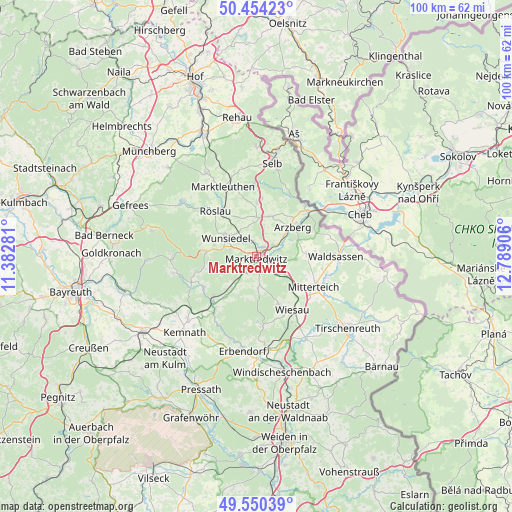
Marktredwitz GPS coordinates[2]
50° 0' 15.948" North, 12° 5' 9.348" East
| Map corner | latitude | longitude |
|---|---|---|
| Upper-left | 50.45423°, | 11.38281° |
| Center: | 50.00443°, | 12.08593° |
| Lower-right: | 49.55039°, | 12.78906° |
| Map W x H: | 100.5×100.5 km | = 62.4×62.4mi |
| max Lat: | 55.01917° ⇑63.6% North |
| Marktredwitz: | 50.00443° |
| min Lat: | ⇓36.4% South 47.40724° |
| min Long | Marktredwitz | max Long |
| 5.92978° | 12.08593° | 14.98853° |
| W 83%⇐ | ⇒17% E |
Elevation
Elevation of Marktredwitz is 539 m = 1768 ft, and this is 289.9 m = 951 ft above average elevation for this country.
| Max E: |
1256 m = 4121 ft | 8.2% |
| Marktredwitz | 539 m 1768 ft | |
| Avg. | 249.1 m = 817 ft | |
Min E: |
-5 m = -16 ft | 91.8% |
See also: Germany elevation on elevation.city.
Geographical zone
Marktredwitz is located in North temperate zone (between Tropic of Cancer and the Arctic Circle). Distance of this North polar circle is 1841.2 km =1144.1 mi to North.| Distance of | km | miles | from Marktredwitz |
|---|---|---|---|
| North Pole | 4447.1 | 2763.3 | to North |
| Arctic Circle | 1841.2 | 1144.1 | to North |
| Tropic Cancer | 2954.1 | 1835.6 | to South |
| Equator | 5560 | 3454.8 | to South |


Nearby cities:
15 places around Marktredwitz: (largest is in red/bold)
• Arzberg
9.3 km =5.8 mi,  50°
50°
• Bad Alexandersbad
5.1 km =3.2 mi,  285°
285°
• Ebnath
12.5 km =7.8 mi,  240°
240°
• Fuchsmühl
10.1 km =6.3 mi,  154°
154°
• Höchstädt bei Thiersheim
10.8 km =6.7 mi,  0°
0°
• Nagel
12.3 km =7.6 mi,  259°
259°
• Neusorg
11.6 km =7.2 mi,  227°
227°
• Pechbrunn
7.1 km =4.4 mi,  126°
126°
• Pullenreuth
10 km =6.2 mi,  217°
217°
• Röslau
11.4 km =7.1 mi,  320°
320°
• Thiersheim
8.5 km =5.3 mi,  19°
19°
• Thierstein
11.4 km =7.1 mi,  5°
5°
• Tröstau
9.8 km =6.1 mi,  277°
277°
• Waldershof
3 km =1.9 mi,  212°
212°
• Wunsiedel
7.1 km =4.4 mi,  303°
303°
Sources, notices
• [Note1] Compared only with cities in Germany existing in our database
• [Src1] Map data: © OpenStreetMap contributors (CC-BY-SA)
• [Src2] Other city data from geonames.org with taken over terms of usage.
• [Src3] Geographical zone / Annual Mean Temperature by Robert A. Rohde @ Wikipedia
