Petting geodata
Petting (Bavaria) is a seat of a fourth-order administrative division; located in Germany in Europe/Berlin (GMT+2) time zone. With population of 2,346 people, there are 4605 cities with bigger population in this country. Compared to other cities in Germany, 96.5% of cities are located further ↑North; 90.9% of cities are located further ←West and 82% of cities have lower elevation than Petting. Note1
Administrative division(s):
- Level 1: Bavaria
- Level 2: Upper Bavaria
- Level 3: Landkreis Traunstein
- Level 4: Petting


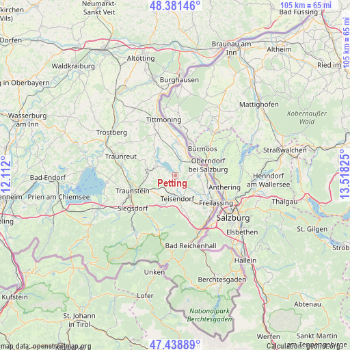
Petting GPS coordinates[2]
47° 54' 44.352" North, 12° 48' 54.432" East
| Map corner | latitude | longitude |
|---|---|---|
| Upper-left | 48.38146°, | 12.112° |
| Center: | 47.91232°, | 12.81512° |
| Lower-right: | 47.43889°, | 13.51825° |
| Map W x H: | 104.8×104.8 km | = 65.1×65.1mi |
| max Lat: | 55.01917° ⇑96.5% North |
| Petting: | 47.91232° |
| min Lat: | ⇓3.5% South 47.40724° |
| min Long | Petting | max Long |
| 5.92978° | 12.81512° | 14.98853° |
| W 90.9%⇐ | ⇒9.1% E |
Elevation
Elevation of Petting is 446 m = 1463 ft, and this is 196.9 m = 646 ft above average elevation for this country.
| Max E: |
1256 m = 4121 ft | 18% |
| Petting | 446 m 1463 ft | |
| Avg. | 249.1 m = 817 ft | |
Min E: |
-5 m = -16 ft | 82% |
See also: Germany elevation on elevation.city.
Geographical zone
Petting is located in North temperate zone (between Tropic of Cancer and the Arctic Circle). Distance of this North polar circle is 2073.8 km =1288.6 mi to North.| Distance of | km | miles | from Petting |
|---|---|---|---|
| North Pole | 4679.7 | 2907.8 | to North |
| Arctic Circle | 2073.8 | 1288.6 | to North |
| Tropic Cancer | 2721.4 | 1691 | to South |
| Equator | 5327.4 | 3310.3 | to South |


Nearby cities:
15 places around Petting: (largest is in red/bold)
• Ainring
14.5 km =9 mi,  139°
139°
• Anger
12.7 km =7.9 mi,  165°
165°
• Freilassing
14.7 km =9.1 mi,  122°
122°
• Fridolfing
9.5 km =5.9 mi,  5°
5°
• Kirchanschöring
4.7 km =2.9 mi,  17°
17°
• Laufen
8.8 km =5.5 mi,  72°
72°
• Nußdorf
16.3 km =10.1 mi,  267°
267°
• Palling
16.6 km =10.3 mi,  306°
306°
• Sankt Leonhard am Wonneberg
7.2 km =4.5 mi, 272°
• Siegsdorf
16.3 km =10.1 mi,  232°
232°
• Surberg
10 km =6.2 mi,  239°
239°
• Taching am See
8.3 km =5.2 mi, 309°
• Teisendorf
7 km =4.3 mi,  177°
177°
• Traunstein
13.7 km =8.5 mi,  249°
249°
• Waging am See
6.5 km =4 mi,  291°
291°
Sources, notices
• [Note1] Compared only with cities in Germany existing in our database
• [Src1] Map data: © OpenStreetMap contributors (CC-BY-SA)
• [Src2] Other city data from geonames.org with taken over terms of usage.
• [Src3] Geographical zone / Annual Mean Temperature by Robert A. Rohde @ Wikipedia
