Teisendorf geodata
Teisendorf (Bavaria) is a populated place; located in Germany in Europe/Berlin (GMT+2) time zone. With population of 9,019 people, there are 1784 cities with bigger population in this country. Compared to other cities in Germany, 97.2% of cities are located further ↑North; 90.9% of cities are located further ←West and 88.4% of cities have lower elevation than Teisendorf. Note1
Administrative division(s):
- Level 1: Bavaria
- Level 2: Upper Bavaria
- Level 3: Berchtesgadener Land
- Level 4: Teisendorf, Markt


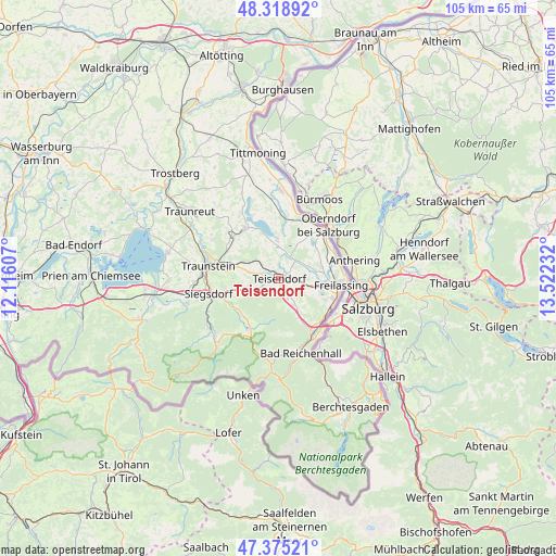
Teisendorf GPS coordinates[2]
47° 50' 57.156" North, 12° 49' 9.084" East
| Map corner | latitude | longitude |
|---|---|---|
| Upper-left | 48.31892°, | 12.11607° |
| Center: | 47.84921°, | 12.81919° |
| Lower-right: | 47.37521°, | 13.52232° |
| Map W x H: | 104.9×104.9 km | = 65.2×65.2mi |
| max Lat: | 55.01917° ⇑97.2% North |
| Teisendorf: | 47.84921° |
| min Lat: | ⇓2.8% South 47.40724° |
| min Long | Teisendorf | max Long |
| 5.92978° | 12.81919° | 14.98853° |
| W 90.9%⇐ | ⇒9.1% E |
Elevation
Elevation of Teisendorf is 498 m = 1634 ft, and this is 248.9 m = 817 ft above average elevation for this country.
| Max E: |
1256 m = 4121 ft | 11.6% |
| Teisendorf | 498 m 1634 ft | |
| Avg. | 249.1 m = 817 ft | |
Min E: |
-5 m = -16 ft | 88.4% |
See also: Germany elevation on elevation.city.
Geographical zone
Teisendorf is located in North temperate zone (between Tropic of Cancer and the Arctic Circle). Distance of this North polar circle is 2080.8 km =1292.9 mi to North.| Distance of | km | miles | from Teisendorf |
|---|---|---|---|
| North Pole | 4686.7 | 2912.2 | to North |
| Arctic Circle | 2080.8 | 1292.9 | to North |
| Tropic Cancer | 2714.4 | 1686.6 | to South |
| Equator | 5320.3 | 3305.9 | to South |


Nearby cities:
15 places around Teisendorf: (largest is in red/bold)
• Ainring
9.9 km =6.2 mi,  113°
113°
• Anger
6 km =3.7 mi,  151°
151°
• Bad Reichenhall
14 km =8.7 mi,  161°
161°
• Freilassing
12.1 km =7.5 mi,  94°
94°
• Inzell
10.8 km =6.7 mi,  207°
207°
• Kirchanschöring
11.6 km =7.2 mi,  5°
5°
• Laufen
12.6 km =7.8 mi,  40°
40°
• Petting
7 km =4.3 mi,  357°
357°
• Piding
11.7 km =7.3 mi,  141°
141°
• Sankt Leonhard am Wonneberg
10.5 km =6.5 mi,  314°
314°
• Siegsdorf
13.5 km =8.4 mi,  257°
257°
• Surberg
9.1 km =5.7 mi,  282°
282°
• Taching am See
14 km =8.7 mi,  331°
331°
• Traunstein
13.3 km =8.3 mi, 279°
• Waging am See
11.4 km =7.1 mi, 326°
Sources, notices
• [Note1] Compared only with cities in Germany existing in our database
• [Src1] Map data: © OpenStreetMap contributors (CC-BY-SA)
• [Src2] Other city data from geonames.org with taken over terms of usage.
• [Src3] Geographical zone / Annual Mean Temperature by Robert A. Rohde @ Wikipedia
